Aeolian Coast
From CruisersWiki
(Difference between revisions)
Istioploos (Talk | contribs) m (New Material) |
Istioploos (Talk | contribs) (Interactive Map) |
||
| Line 2: | Line 2: | ||
An online cruising guide for yachts sailing around the Aeolian Coast of [[Turkey]]. | An online cruising guide for yachts sailing around the Aeolian Coast of [[Turkey]]. | ||
| - | + | <imagemap> | |
| - | | | + | Image:TurkeyAeolian.jpg|frame|center|The Turkish Aeolian Coast - <em>For details click on a name or an area</em> |
| - | | | + | rect 408 107 441 164 [[Ayvalik#Alibey|Alibey]] |
| - | | | + | rect 346 121 401 146 [[Ayvalik#Maden_Adasi|Maden or Poroselene Adasi]] |
| - | | | + | poly 412 170 493 165 493 199 417 199 [[Ayvalik]] |
| - | + | rect 344 173 400 205 [[Ayvalik#Ciplak_Adasi|Ciplak Adasi]] | |
| + | rect 483 306 537 340 [[Dikili]] | ||
| + | rect 478 347 557 381 [[Eskifoca_Region#Bademli_Liman|Bademli Liman]] | ||
| + | rect 517 391 577 426 [[Eskifoca_Region#Çandarli|Çandarli]] | ||
| + | rect 410 560 472 588 [[Eskifoca_Region#Eskifoça|Foça or Eskifoça]] | ||
| + | rect 339 570 386 607 [[Izmir#Saip_Alti|Saip Alti or Saipaltı Balıkçı Barınağı]] | ||
| + | rect 570 700 688 745 [[Izmir]] | ||
| + | rect 234 630 296 666 [[Cesme#Egri_Liman|Egri Liman]] | ||
| + | rect 221 700 278 732 [[Cesme#Kara_Adasi|Kara Adasi]] | ||
| + | rect 153 777 242 805 [[Cesme|Çesme]] | ||
| + | poly 155 744 230 744 235 744 265 770 265 779 229 776 155 776 [[Setur_Cesme_Marina|Setur Çesme Marina]] | ||
| + | poly 251 739 291 739 291 763 254 763 [[Cesme#Dalyan_Ildur|Dalyan Ildur]] | ||
| + | poly 245 816 283 816 275 785 262 785 [[Cesme#Ilica|Ilica]] | ||
| + | rect 295 731 334 755 [[Cesme#Ildir|Ildir]] | ||
| + | </imagemap> | ||
| + | |||
| + | {{TOCleft}} | ||
The Aeolian Coast is less frequently visited by yachts then the coasts of [[Turkey]] to the south. It takes its name from the ancient city of [http://en.wikipedia.org/wiki/Aeolis Aeolis]. It extends south of the [[Dardanelles]] to [[Ayvalik]], Gulf of [[Izmir]], and [[Cesme|Çesme]]. | The Aeolian Coast is less frequently visited by yachts then the coasts of [[Turkey]] to the south. It takes its name from the ancient city of [http://en.wikipedia.org/wiki/Aeolis Aeolis]. It extends south of the [[Dardanelles]] to [[Ayvalik]], Gulf of [[Izmir]], and [[Cesme|Çesme]]. | ||
| Line 101: | Line 117: | ||
| - | {{ | + | {{Guide2}} |
Revision as of 20:51, 18 February 2015
Aeolian Coast Cruising Guide
An online cruising guide for yachts sailing around the Aeolian Coast of Turkey.
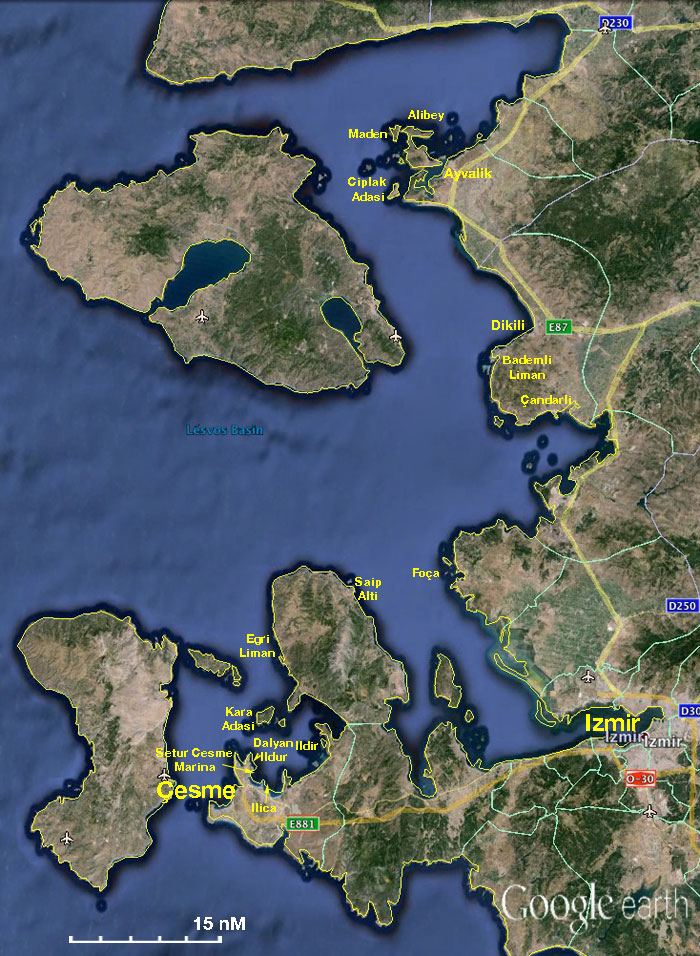

The Turkish Aeolian Coast - For details click on a name or an area
|
The Aeolian Coast is less frequently visited by yachts then the coasts of Turkey to the south. It takes its name from the ancient city of Aeolis. It extends south of the Dardanelles to Ayvalik, Gulf of Izmir, and Çesme.
- BA
- 1087 Kólpos Petalión to Edremit Körfezi
- 1645 Nísos Khíos and Izmir Körfezi
- 1665 Nisos Lesvos and Çandarli Korfezi to Baba Burnu Ayvalik
- Imray-Tetra
- G2 Aegean Sea (North)
- G28 Nísos Khíos & the Coast of Turkey
- G23 Eastern Sporades
- NIMA
- 54380 Tuzla Burnu to Samos including Adjacent Islands
- 54382 Nisos Lesvos and Western Coast of Turkey
- 54389 Fener Adasi to Samos Strait
- Turkey
- 2145 Edremit Körfezi
- 2147 Çandarlı Körfezi
- 2212 İzmir Limanı
- 2223 Gerence - Ildır Körfezi
- 2224 Süngükaya Geçidi
- Greek
- 332 Lesvos Island
- 334 Chios Island & Opposite Coast of Asia Minor
Weather and Winds
See Turkey.
Currents & Tides
These are weak.
Regional Radio Nets
Also see World Cruiser's Nets.
Ports, Anchorages, and Islands
![]() = Island,
= Island, ![]() = Port of entry,
= Port of entry, ![]() = Marina,
= Marina, ![]() = Harbor,
= Harbor, ![]() = Anchorage,
= Anchorage, ![]() = Needs data.
= Needs data.
From north to south:
Routes/Passages To/From
Cruiser's Friends
Contact details of "Cruiser's Friends" that can be contacted for local information or assistance.
Forum Discussions
List links to discussion threads on partnering forums. (see link for requirements)
External Links
References & Publications
See Turkey.
Personal Notes
Personal experiences?
|
|---|
|
Names: Istioploos |
| |
|---|
| | HOMEPAGE | Wiki Contents | Mediterranean | Turkey | Aegean Sea | Aeolian Coast | |