Dardanelles
From CruisersWiki
Istioploos (Talk | contribs) (Chartlet) |
m (Text replace - "==References & Publications==" to "==References==") |
||
| (16 intermediate revisions not shown) | |||
| Line 1: | Line 1: | ||
| - | + | {{IsPartOf|Mediterranean|Aegean Sea|Turkey}} | |
| + | {{Page imagemap|clear=y}} | ||
| - | { | + | {{TOC block}} |
| - | + | ||
| - | + | ||
| - | + | ||
| - | + | ||
| - | + | ||
| - | + | ||
| - | + | ||
| - | + | ||
| - | + | ||
| - | + | ||
| - | + | ||
| - | + | ||
| - | + | ||
| - | + | ||
| - | {{ | + | {{Image right| Turkey_Dardanelles_r.jpg| Chart of the Dardanelles }} |
| - | + | {{Image right|AlliedMonument.jpg |The Allied war memorial on the N side of the entrance }} | |
| - | + | ||
| - | + | ||
| - | | | + | |
| - | }} | + | |
| - | + | ||
| - | {{Image right|AlliedMonument.jpg |The Allied war memorial on the N side of the entrance | + | |
{{Image right|TurkishMonument.jpg |The Turkish war memorial on the N side of the entrance <br /> ''Click for larger view'' }} | {{Image right|TurkishMonument.jpg |The Turkish war memorial on the N side of the entrance <br /> ''Click for larger view'' }} | ||
| - | The [http://en.wikipedia.org/wiki/Dardanelles Dardanelles] (Turkish: Çanakkale Boğazı, Greek: Δαρδανέλλια, Dardanellia), laterly known as the Hellespont (Greek: Ελλήσποντος, Hellespontos), is a narrow strait in northwestern [[Turkey]] connecting the Aegean Sea to the [[Sea of Marmara]] | + | The [http://en.wikipedia.org/wiki/Dardanelles Dardanelles] (Turkish: Çanakkale Boğazı, Greek: Δαρδανέλλια, Dardanellia), laterly known as the Hellespont (Greek: Ελλήσποντος, Hellespontos), is a narrow strait in northwestern [[Turkey]] connecting the Aegean Sea to the {{mark | lat=40.71396 |lon=28.09753 | type= waypoint |name= [[Sea of Marmara]]| zoom= 8}}. The strait is 33 nM (61 km or 38 mi) long but only 0.65 to 3.2 nM (1.2 to 6 km or 0.75 to 4 mi) wide, averaging 55 meters (180 ft) deep with a maximum depth of 82 meters (300 ft). Water flows in both directions along the strait, from the Sea of Marmara to the Aegean via a surface current and in the opposite direction via an undercurrent. |
Like the [[Bosphorus]], it separates Europe (in this case the Gallipoli peninsula) and the mainland of Asia. The strait is an international waterway, and together with the [[Bosphorus]], the Dardanelles connects the [[Black Sea]] to the [[Mediterranean|Mediterranean Sea]]. | Like the [[Bosphorus]], it separates Europe (in this case the Gallipoli peninsula) and the mainland of Asia. The strait is an international waterway, and together with the [[Bosphorus]], the Dardanelles connects the [[Black Sea]] to the [[Mediterranean|Mediterranean Sea]]. | ||
| Line 34: | Line 15: | ||
According to the [http://en.wikipedia.org/wiki/Montreux_Convention Montreux Convention] of 1936, still in force today, the straits are an international shipping lane but Turkey retains the right to restrict the naval traffic of non-Black Sea nations (like Greece or Algeria). During World War II, when Turkey was neutral for almost the entire length of the conflict, the Dardanelles were closed to the ships of the belligerent nations. | According to the [http://en.wikipedia.org/wiki/Montreux_Convention Montreux Convention] of 1936, still in force today, the straits are an international shipping lane but Turkey retains the right to restrict the naval traffic of non-Black Sea nations (like Greece or Algeria). During World War II, when Turkey was neutral for almost the entire length of the conflict, the Dardanelles were closed to the ships of the belligerent nations. | ||
| - | |||
| - | |||
| - | |||
==Charts== | ==Charts== | ||
| Line 54: | Line 32: | ||
: 109 Ionio-Aegeo Steno Messinis mechri Thalassa Marmara | : 109 Ionio-Aegeo Steno Messinis mechri Thalassa Marmara | ||
| - | == | + | ==Weather== |
| - | * | + | ''See [[Turkey#Weather|Turkey]]''. |
| + | |||
| + | ==Passages== | ||
| + | * [[N_-_S_Passages_in_East_Aegean#Marmaris_to_G.C3.B6k.C3.A7eada|Marmaris to Çanakkale]] | ||
| + | * [[N - S Passages in East Aegean]] | ||
| + | |||
| + | ==Communication== | ||
| + | {{Green|Add here VHF channel for coastguard, harbor masters. etc.}} | ||
| + | * | ||
* | * | ||
''Also see [[World MM Nets|World Cruiser's Nets]]'' | ''Also see [[World MM Nets|World Cruiser's Nets]]'' | ||
| - | == | + | ==Navigation== |
| - | + | ||
| - | + | ||
| - | + | ||
The Dardanelles is a very busy channel with a lot of ship traffic. There is a separation zone with eastbound ships staying on the south shore and westbound ships staying on the north shore. Yachts transiting the straits should keep outside the charted shipping lanes (which is in any case a wise move for a northbound yacht in view of the strong adverse currents). | The Dardanelles is a very busy channel with a lot of ship traffic. There is a separation zone with eastbound ships staying on the south shore and westbound ships staying on the north shore. Yachts transiting the straits should keep outside the charted shipping lanes (which is in any case a wise move for a northbound yacht in view of the strong adverse currents). | ||
| Line 69: | Line 52: | ||
A northbound yacht is best advised to stay close inshore on the southern side of the straits, following the 10.0 – 15.0 metre contour where the current is weaker. This course is actually quicker and has the added advantage of keeping a yacht well clear of the shipping lanes. | A northbound yacht is best advised to stay close inshore on the southern side of the straits, following the 10.0 – 15.0 metre contour where the current is weaker. This course is actually quicker and has the added advantage of keeping a yacht well clear of the shipping lanes. | ||
| + | |||
| + | ==Entrance== | ||
| + | ''See [[Turkey#Entrance|Turkey]]''. | ||
==Countries, Ports, Anchorages, and Islands== | ==Countries, Ports, Anchorages, and Islands== | ||
| Line 83: | Line 69: | ||
** {{dest| Samothrace |i|h}} | ** {{dest| Samothrace |i|h}} | ||
| - | == | + | ==Friends== |
| - | + | ||
| - | + | ||
| - | + | ||
| - | + | ||
Submit details/contacts of cruiser's "friends" that can be contacted in advance or on arrival - who can offer information and assistance to our cruising "family". | Submit details/contacts of cruiser's "friends" that can be contacted in advance or on arrival - who can offer information and assistance to our cruising "family". | ||
| - | == | + | ==Forums== |
List links to discussion threads on [[Cruising Forums|partnering forums]]. (''see link for requirements'') | List links to discussion threads on [[Cruising Forums|partnering forums]]. (''see link for requirements'') | ||
* | * | ||
* | * | ||
| - | == | + | ==Links== |
| - | * | + | * {{Wikipedia}} |
* | * | ||
* | * | ||
| - | ==References | + | ==References== |
See [[Turkey#References_&_Publications|Turkey]]. | See [[Turkey#References_&_Publications|Turkey]]. | ||
| - | + | {{Comments}} | |
| - | + | ||
* Leaving from the Turkish island of [[Bozcaada]], a yacht motoring at 6.5 knots should be able to make [[Canakkale]] within six hours following the route above. The port of [[Lapseki]] takes a further four hours at the same rate of progress.--[[User:Atheneoflymington|Athene of Lymington]] 16:30, 18 May 2011 (BST) | * Leaving from the Turkish island of [[Bozcaada]], a yacht motoring at 6.5 knots should be able to make [[Canakkale]] within six hours following the route above. The port of [[Lapseki]] takes a further four hours at the same rate of progress.--[[User:Atheneoflymington|Athene of Lymington]] 16:30, 18 May 2011 (BST) | ||
* | * | ||
| - | + | {{Verified by}} | |
| - | + | ||
* August 1999 --[[User:Istioploos|Istioploos]] 13:24, 6 July 2008 (MDT) | * August 1999 --[[User:Istioploos|Istioploos]] 13:24, 6 July 2008 (MDT) | ||
* May 2011--[[User:Atheneoflymington|Athene of Lymington]] 16:30, 18 May 2011 (BST) | * May 2011--[[User:Atheneoflymington|Athene of Lymington]] 16:30, 18 May 2011 (BST) | ||
| Line 119: | Line 99: | ||
{{Contributors|[[User:Istioploos|Istioploos]], [[User:Atheneoflymington|Athene of Lymington]]}} | {{Contributors|[[User:Istioploos|Istioploos]], [[User:Atheneoflymington|Athene of Lymington]]}} | ||
| - | |||
| - | |||
| - | |||
[[Category:Regions - Turkey]] | [[Category:Regions - Turkey]] | ||
Latest revision as of 11:47, 15 August 2018
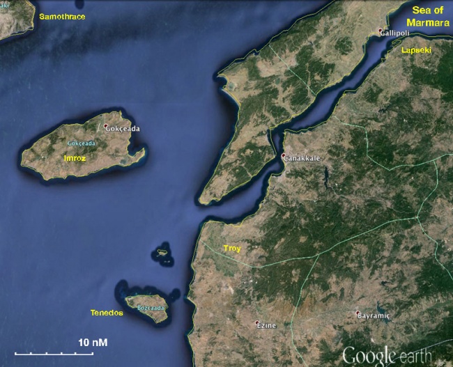  The Dardanelles - For details click on a name or an area |


Click for larger view
The Dardanelles (Turkish: Çanakkale Boğazı, Greek: Δαρδανέλλια, Dardanellia), laterly known as the Hellespont (Greek: Ελλήσποντος, Hellespontos), is a narrow strait in northwestern Turkey connecting the Aegean Sea to the ![]() Sea of Marmara [[Dardanelles#Sea of Marmara|Sea of Marmara]] 40°42.838'N, 028°05.852'E . The strait is 33 nM (61 km or 38 mi) long but only 0.65 to 3.2 nM (1.2 to 6 km or 0.75 to 4 mi) wide, averaging 55 meters (180 ft) deep with a maximum depth of 82 meters (300 ft). Water flows in both directions along the strait, from the Sea of Marmara to the Aegean via a surface current and in the opposite direction via an undercurrent.
Sea of Marmara [[Dardanelles#Sea of Marmara|Sea of Marmara]] 40°42.838'N, 028°05.852'E . The strait is 33 nM (61 km or 38 mi) long but only 0.65 to 3.2 nM (1.2 to 6 km or 0.75 to 4 mi) wide, averaging 55 meters (180 ft) deep with a maximum depth of 82 meters (300 ft). Water flows in both directions along the strait, from the Sea of Marmara to the Aegean via a surface current and in the opposite direction via an undercurrent.
Like the Bosphorus, it separates Europe (in this case the Gallipoli peninsula) and the mainland of Asia. The strait is an international waterway, and together with the Bosphorus, the Dardanelles connects the Black Sea to the Mediterranean Sea.
The Turkish name Çanakkale Boğazı is derived from the major city adjoining the strait, Çanakkale (which takes its name from its famous castles; kale means "castle"). The name Dardanelles derives from Dardania, an ancient land (founded by Dardanus) on the Asian shore of the strait.
According to the Montreux Convention of 1936, still in force today, the straits are an international shipping lane but Turkey retains the right to restrict the naval traffic of non-Black Sea nations (like Greece or Algeria). During World War II, when Turkey was neutral for almost the entire length of the conflict, the Dardanelles were closed to the ships of the belligerent nations.
Charts
- BA
- 1004 Çhannakale boğazi
- 1086 Srimonikos kólpos to Edremit körfezi
- NIMA
- 55040 Sea of Marmara
- 55041 Canakkale Bogazi
- Turkey
- 29 Marmara Sea
- 295 Hoşköy - Gelibolu
- 2111 Saros Körfezi
- 2134 Anafartalar Koyu - Tavşan Island
- 2131 Gelibolu Yarımadası - Gökçeada
- Greek
- 109 Ionio-Aegeo Steno Messinis mechri Thalassa Marmara
Weather
See Turkey.
Passages
Communication
Add here VHF channel for coastguard, harbor masters. etc.
Also see World Cruiser's Nets
The Dardanelles is a very busy channel with a lot of ship traffic. There is a separation zone with eastbound ships staying on the south shore and westbound ships staying on the north shore. Yachts transiting the straits should keep outside the charted shipping lanes (which is in any case a wise move for a northbound yacht in view of the strong adverse currents).
These adverse currents flow from the Sea of Marmara to the Aegean and make a reasonably powerful engine an essential requirement for a northbound yacht, especially since sailing is usually impossible in view of the prevailing winds blowing down the straits and the folly of attempting to tack across the shipping lanes. The current reaches up to 3.5 – 4.0 knots at the Aegean entrance to the straits, especially around the headland of Kumkale Burnu on the southern side and in the narrows N and S of Canakkale. Once beyond Canakkale the current slackens gradually from 3.0 knots down to 1.0 – 1.5 knots as a yacht enters the wider part between Nara Burnu N of Canakkale and the port of Gelibolu.
A northbound yacht is best advised to stay close inshore on the southern side of the straits, following the 10.0 – 15.0 metre contour where the current is weaker. This course is actually quicker and has the added advantage of keeping a yacht well clear of the shipping lanes.
Entrance
See Turkey.
Countries, Ports, Anchorages, and Islands
-
- Lapseki |
 – harbour |
-
Friends
Submit details/contacts of cruiser's "friends" that can be contacted in advance or on arrival - who can offer information and assistance to our cruising "family".
Forums
List links to discussion threads on partnering forums. (see link for requirements)
Links
- Dardanelles at the Wikipedia
References
See Turkey.
Comments
We welcome users' contributions to the Wiki. Please click on Comments to view other users' comments, add your own personal experiences or recommend any changes to this page following your visit.
- Leaving from the Turkish island of Bozcaada, a yacht motoring at 6.5 knots should be able to make Canakkale within six hours following the route above. The port of Lapseki takes a further four hours at the same rate of progress.--Athene of Lymington 16:30, 18 May 2011 (BST)
Verified by
Date of member's last visit to Dardanelles and this page's details validated:
- August 1999 --Istioploos 13:24, 6 July 2008 (MDT)
- May 2011--Athene of Lymington 16:30, 18 May 2011 (BST)
| This is a usable page of the cruising guide. However, please contribute if you can to help it grow further. Click on Comments to add your personal notes on this page or to discuss its contents. Alternatively, if you feel confident to edit the page, click on the edit tab at the top and enter your changes directly. |
| |
|---|
|
Names: Istioploos, Athene of Lymington |