Gulluk Korfesi
From CruisersWiki
Gülluk Körfesi
| | |
| | 37°14.4′N, 27°35.6′E |
|---|---|
| | Photo gallery |
| | Local chartlet |
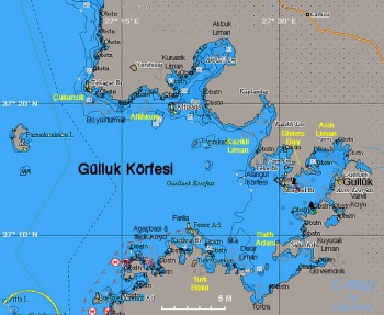 Chart of the Gülluk Körfesi - Click for larger view Chart of the Gülluk Körfesi - Click for larger view
| |
This gulf is NE of the island of Kos and the port of Bodrum and SE of the island of Samos and the port of Kusadasi. The gulf is home to scores of fish farms some of which are poorly marked and would be confusing at night. They seem professionally run and there is little sign of pollution.
Charts
- BA
- 1546 Samos Strait to Güllük Körfezi
- Imray-Tetra
- G35 Dodecanese and Coast of Turkey
- NIMA
- 54400 Nisos Samos to Nisos Rhodhos
- Turkey
- 2245 Kovala Limanı - Akbük Limanı
- 2246 Kazıklı Limanı - Asin Körfezi
- 2247 Torba Limanı
- 2248 Gündoğan Limanı - Kadıkalesi
- Greek
- 451 Leros to Rhodos
- 422 Naxos to Samos & Opposite Coast of Asia Minor
Radio Nets
Also see World Cruiser's Nets.
Local Weather
See Turkey.
In general, the approach into the gulf and its anchorages is easy and presents no dangers.
Check-in facilities (for Customs and Immigration)
The closest port of entry is Gülluk.
Berthing Options
Ports
- Gülluk (Port of Entry)
Marinas & Yacht Clubs
Anchorages
Türk Bükü
![]() 37°08′N, 27°23′E
37°08′N, 27°23′E
Türk Bükü was originally called Rum Bükü and was Greek village. Today it is an attractive up market resort with lovely shops and restaurants surrounding a perfectly clear bay. There is a small marina (tel +90 252 377 6128 /+90 536 899 2673 - Mehmet) in the South corner of the harbor (E$ 50/ night plus water & elec stern to with laid lines. Fuel available by tanker truck at the marina. Fuel also available from a lighter that comes through the harbour. The marina also controls a number of fixed moorings in the harbour. Other mooring services are offered on VHF69 tel +90 530 312 9966. Alternately,try to anchor among the moorings in the harbour or anchor moor in 30 metres with a line ashore to the rocks in the north west corner behind Bueyuek Ad. One of the prettiest harbours in the area.
Note: there is an unmarked, seemingly abandoned fish farm floating low in the water to the East of Kucuktavsan Ad 37:10.9n 027:22.6e
Last Visited & Details Checked (and updated here)
Date of member's visit to this Port/Stop & this page's details validated:
- June 1990 --Istioploos

- June 2013 --Monterey

Asin Liman
![]() 37°16.5′N, 27°35′E
37°16.5′N, 27°35′E
Asin Liman or Port Isene or Kuria is an ancient harbor (formerly Iasos) in the almost landlocked Asin Körfezi. It a pleasant anchorage surrounded by the ruins of the ancient city and overlooked by a walled acropolis. Anchor moor to the quay if you can find space. Depths at the quay are a bit over over 2 meters but greater than 2.5 meters a couple of meters off. Water and electricity can be arranged on the quay. A local official will come by to collect 30tl. The bottom here is mud and provides good holding. Good shelter in the prevailing winds. Iassos used to be supplied with several good restaurants, there were two relatively modest ones in operation on a visit in June 2013.
Danger: The ancient breakwater is submerged and not always visible. The approach should be made some 15-20 meters off the old Byzantine tower on the starboard side.
Warning: With strong southerlies the anchorage is uncomfortable and may be dangerous.
Last Visited & Details Checked (and updated here)
Date of member's visit to this Port/Stop & this page's details validated:
- June 1990 --Istioploos

- May 2010 --Athene of Lymington 18:49, 12 May 2010 (UTC)
- June 2013 --Monterey

Shiero Bay
![]() 37°14.7′N, 27°32.4′E
37°14.7′N, 27°32.4′E
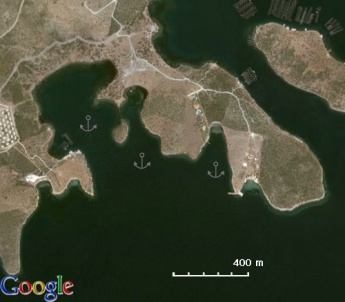
Shiero Bay is almost landlocked and is an excellent shelter from the meltemi. It is very pleasant, with pine trees, except for the huge holiday development that now overlooks it. Anchor in 6-8 m over mud. Good holding.
Last Visited & Details Checked (and updated here)
Date of member's visit to this Port/Stop & this page's details validated:
- June 1990 --Istioploos

- June 2012 --Vigdis
Kazikli Liman
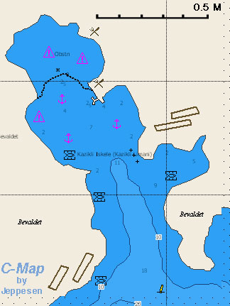 Chart of Kazikli Liman - Chartlet Chart of Kazikli Liman - Chartlet
|
![]() 37°19.2′N, 27°28.8′E
37°19.2′N, 27°28.8′E
A large bay with several mooring possibilities in very pleasant wooded surroundings. Either anchor in 5-7 m over sand or go on the wooden restaurant jetty (Kaptan Han telephone: +90 252 565 0022) on the eastern side where there is space for 6-8 yachts with a mooring line (in which case you will obviously be expected to eat in the restaurant). The mooring weights are a bit close to the dock (18m) and anchor mooring is advised for larger boats. Depths are >3 metres alongside the pontoons. Watch for stray lines on backing in. Free water and electricity at the limited connections. Good protection from the meltemi. Other restaurants ashore.
Warning: There are a lot of mosquitos here.
Last Visited & Details Checked (and updated here)
Date of member's visit to this Port/Stop & this page's details validated:
- June 1990 --Istioploos

- September 2006 --Atheneoflymington 14:48, 24 July 2009 (UTC)
- June 2012 --Vigdis
- June 2013 --Monterey

Altinkum
![]() 37°21.2′N, 27°16.8′E
37°21.2′N, 27°16.8′E
Altinkum or Skrophes Bay or Karakuyu is a popular resort and a an excellent place to leave the yacht for a visit to Didyma. Anchor in the NW corner in 3-4 m on sand. Good holding and shelter from the meltemi.
Warning: The town is extremely noisy at night so anchor at some distance.
Last Visited & Details Checked (and updated here)
Date of member's visit to this Port/Stop & this page's details validated:
- August 2004 --Istioploos

Çukurcuk
![]() 37°21′N, 27°12.4′E
37°21′N, 27°12.4′E
There are two anchorages here: the E and the W creeks. Clear water. Anchor in 2-4 m. Shelter is reasonably good from the prevailing northerlies, although a swell creeps round the corner.
Last Visited & Details Checked (and updated here)
Date of member's visit to this Port/Stop & this page's details validated:
- August 2004 --Istioploos

- September 2006 --Atheneoflymington 14:44, 24 July 2009 (UTC)
Offshore Islands
Salih Adasi
![]() 37°09′N, 27°32′E
37°09′N, 27°32′E
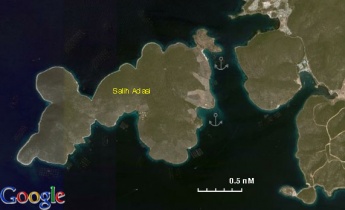
Salih Adasi appears to be a private island. There are several anchoring possibilities and the shelter is good.
Last Visited & Details Checked (and updated here)
Date of member's visit to this Port/Stop & this page's details validated:
- June 1990 --Istioploos

Yacht Repairs and Services
Marine Stores
In Didim Marina.
Repairs/Yards
All services in Didim Marina.
Fuel, Water, & Electricity
- Fuel
- In Gülluk
- In Didim Marina
- Water
- In Gülluk
- In Didim Marina
- At Kaptan Han in Kazikli Liman
- Maybe at some seaside restaurants
- Electricity
- In Didim Marina
- At Kaptan Han in Kazikli Liman
- Maybe at some seaside restaurants
Things to do Ashore
Tourism
Asin Liman
A climb to the ancient fort of Iassus is must. The city was founded by the Peloponnesians in about 900 BC.
Didyma
Didyma which is only about 4 km inland from Altinkum. The Hellenistic Ionic temple of Apollo at Didyma is very large, impressive, and in good preservation. Here was an oracle of Apollo, the most renowned in antiquity after the oracle of Delphi. A must see site.
Grocery & Supply Stores
Eateries
Internet/WiFi
?
Motorbike & Car Rentals
- Car rentals are possible in Altinkum
Garbage Disposal
There are bins in some anchorages.
Transportation
Routes/Passages To/From
Cruiser's Friends
Contact details of "Cruiser's Friends" that can be contacted for local information or assistance.
Forum Discussions
List links to discussion threads on partnering forums. (see link for requirements)
External Links
References & Publications
See Turkey.
Personal Notes
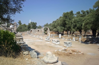
- A picnic in the ancient theatre at Iasos, now shaded by an olive grove, is a memorable experience. September 2006 --Atheneoflymington 14:40, 24 July 2009 (UTC)
Last Visited & Details Checked (and updated here)
See individual ports, anchorages, and islands in this page.
|
|---|
|
Names: Istioploos, Atheneoflymington, Monterey |
| |
|---|
| | HOMEPAGE | Wiki Contents | Mediterranean | Aegean Sea | Turkey | Gulluk Korfesi | |


