Patraikos Kolpos
From CruisersWiki
m (→Last Visited & Details Checked (and updated here)) |
Istioploos (Talk | contribs) (Chartlet) |
||
| Line 1: | Line 1: | ||
| - | |||
An online cruising guide for yachts sailing around the Patraikos Kolpos. | An online cruising guide for yachts sailing around the Patraikos Kolpos. | ||
| - | |||
| - | {{TOCleft}} | + | <imagemap> |
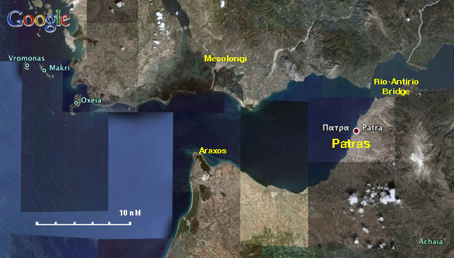
| + | Image:Greece_GulfOfPatras.jpg|frame|center|Gulf of Patras - <em>For details click on a name or an area</em> | ||
| + | rect 282 201 332 249 [[Patraikos_Kolpos#Araxos|Araxos]] | ||
| + | rect 453 171 554 223 [[Patras]] | ||
| + | rect 510 107 595 150 [[Patraikos_Kolpos#Rio-Antirio Bridge|Rio-Antirio Bridge]] | ||
| + | rect 285 71 363 160 [[Mesolongi]] | ||
| + | rect 95 128 139 173 [[Patraikos_Kolpos#Oxia|Oxia]] | ||
| + | </imagemap>{{TOCleft}} | ||
| + | |||
Patraikos Kolpos (Πατραϊκός Κόλπος) or [http://en.wikipedia.org/wiki/Gulf_of_Patras Gulf of Patras] is dominated by the large commercial harbor of [http://en.wikipedia.org/wiki/Patras Patras] ([[Patras|Πάτρα]]) the third largest city in Greece. It is bounded on the west by the Ionian Sea, to the north by mainland Greece, to the east by the [[#Rio-Antirio_Bridge|Rio-Antirio strait]] leading to the [[Korinthiakos_Kolpos|Gulf of Corinth]], and to the south by northern Peloponnese. The gulf is not a favored cruising ground but a passage route of yachts coming or going from the Ionian Sea to the Aegean. Nevertheless there are here several pleasant ports and anchorages. | Patraikos Kolpos (Πατραϊκός Κόλπος) or [http://en.wikipedia.org/wiki/Gulf_of_Patras Gulf of Patras] is dominated by the large commercial harbor of [http://en.wikipedia.org/wiki/Patras Patras] ([[Patras|Πάτρα]]) the third largest city in Greece. It is bounded on the west by the Ionian Sea, to the north by mainland Greece, to the east by the [[#Rio-Antirio_Bridge|Rio-Antirio strait]] leading to the [[Korinthiakos_Kolpos|Gulf of Corinth]], and to the south by northern Peloponnese. The gulf is not a favored cruising ground but a passage route of yachts coming or going from the Ionian Sea to the Aegean. Nevertheless there are here several pleasant ports and anchorages. | ||
| Line 25: | Line 31: | ||
The prevailing wind in Patraikos Kolpos in the summer is from the west and it rarely exceeds force 6. Like the ''meltemi'' it reaches it peak in the middle of the day and subsides in the evening. In the autumn and spring the wind can be either from the east or from the west. | The prevailing wind in Patraikos Kolpos in the summer is from the west and it rarely exceeds force 6. Like the ''meltemi'' it reaches it peak in the middle of the day and subsides in the evening. In the autumn and spring the wind can be either from the east or from the west. | ||
| - | + | {{Danger}} From the late autumn to the early spring the weather can be very volatile with violent thunderstorms and waterspouts. | |
==Approach and Navigation== | ==Approach and Navigation== | ||
| - | + | {{Warning}} The northwestern shores of the gulf, near Messolongi, are a shallow marshland difficult to navigate as charts can be unreliable due to shifting conditions. | |
====Rio-Antirio Bridge==== | ====Rio-Antirio Bridge==== | ||
| Line 45: | Line 51: | ||
===Anchorages=== | ===Anchorages=== | ||
| - | + | {{Poi |38|12.19|N|21|25.24|E| | type= anchorage| name= Araxos | |
| - | + | | text= Araxos (Άραξος) is a large sandy beach just E of Cape Papas in NW Peloponnesos near the entrance to the Gulf of Patras. It is pleasant place to anchor for a lunch stop. }} | |
| - | Araxos (Άραξος) is a large sandy beach just E of Cape Papas in NW Peloponnesos near the entrance to the Gulf of Patras. It is pleasant place to anchor for a lunch stop. | + | |
===Offshore Islands=== | ===Offshore Islands=== | ||
| - | + | {{Poi |37|22.4|N|26|45.2|E| | type= island| name= Oxia | |
| - | + | | text= [http://en.wikipedia.org/wiki/Oxeia Oxía] (Οξεία) is a small island NW of the Gulf of Patras. There three possible anchorages none of which is very good. I have only anchored on the N cove. The physical beauty of the place is despoiled by a fish farm which pollutes the water. There are many goats. | |
| - | [http://en.wikipedia.org/wiki/Oxeia Oxía] (Οξεία) is a small island NW of the Gulf of Patras. There three possible anchorages none of which is very good. I have only anchored on the N cove. The physical beauty of the place is despoiled by a fish farm which pollutes the water. There are many goats. | + | |
| - | Anchor in about 10 m and take a line ashore. | + | Anchor in about 10 m and take a line ashore. }} |
==Yacht Repairs and Services== | ==Yacht Repairs and Services== | ||
| Line 113: | Line 117: | ||
====Last Visited & Details Checked (and updated here)==== | ====Last Visited & Details Checked (and updated here)==== | ||
''Date of member's visit to this Port/Stop & this page's details validated'': | ''Date of member's visit to this Port/Stop & this page's details validated'': | ||
| - | * July 1995 | + | * July 1995 {{Istioploos2}} |
* 2013 --[[User:Vigdis|Vigdis]] [[File:Sailboat favicon.png]] [http://yachtvigdis.wordpress.com yachtvigdis blog] | * 2013 --[[User:Vigdis|Vigdis]] [[File:Sailboat favicon.png]] [http://yachtvigdis.wordpress.com yachtvigdis blog] | ||
| - | + | * | |
| - | {{ | + | {{Page useable}} |
| - | + | {{Contributors|[[User:Istioploos|Istioploos]]}} | |
| - | { | + | |
| - | + | ||
| - | | | + | |
| - | + | ||
| - | + | ||
| - | + | ||
| - | + | ||
| - | + | {{Navbar| [[Mediterranean]] | [[Ionian Sea]] | [[Greece]] | [[Patraikos Kolpos]] }} | |
| - | { | + | |
| - | + | ||
| - | + | ||
| - | + | ||
| - | + | ||
| - | + | ||
[[Category:Regions - Greece]] [[Category:Ports - Greece]] [[Category:Anchorages - Greece]] | [[Category:Regions - Greece]] [[Category:Ports - Greece]] [[Category:Anchorages - Greece]] | ||
Revision as of 21:45, 10 May 2015
An online cruising guide for yachts sailing around the Patraikos Kolpos.

|
Patraikos Kolpos (Πατραϊκός Κόλπος) or Gulf of Patras is dominated by the large commercial harbor of Patras (Πάτρα) the third largest city in Greece. It is bounded on the west by the Ionian Sea, to the north by mainland Greece, to the east by the Rio-Antirio strait leading to the Gulf of Corinth, and to the south by northern Peloponnese. The gulf is not a favored cruising ground but a passage route of yachts coming or going from the Ionian Sea to the Aegean. Nevertheless there are here several pleasant ports and anchorages.
Charts
- BA
- 1676 Prokopos Patron and entrance to Korintiakós Kólpos
- Imray-Tetra
- G13 Gulfs of Patras and Corinth
- NIMA
- 54287 PatraikosKolpos & Approaches
- Greek
- 40 Patraikos Kolpos
Radio Nets
- Coast Guard - VHF channel 12
- Olympia Radio - VHF channel 85
Also see World Cruiser's Nets.
Weather
The prevailing wind in Patraikos Kolpos in the summer is from the west and it rarely exceeds force 6. Like the meltemi it reaches it peak in the middle of the day and subsides in the evening. In the autumn and spring the wind can be either from the east or from the west.
Danger: From the late autumn to the early spring the weather can be very volatile with violent thunderstorms and waterspouts.
Warning: The northwestern shores of the gulf, near Messolongi, are a shallow marshland difficult to navigate as charts can be unreliable due to shifting conditions.
Rio-Antirio Bridge
The Rio-Antirio bridge was completed in the summer of 2004.
Contact 'Rion Traffic' on VHF 14 when 5 miles from the bridge for instructions on which span to use. They will ask your LOA and air-draft. Small craft normally use the starboard side of the channel, bigger ships the central span.
Ports, Anchorages, and Islands
Ports
Marinas & Yacht Clubs
Anchorages
Araxos
Offshore Islands
Oxia
Oxía (Οξεία) is a small island NW of the Gulf of Patras. There three possible anchorages none of which is very good. I have only anchored on the N cove. The physical beauty of the place is despoiled by a fish farm which pollutes the water. There are many goats.
Anchor in about 10 m and take a line ashore.Yacht Repairs and Services
Marine Stores
See individual ports.
Repairs/Yards
See individual ports.
Fuel, Water, & Electricity
See individual ports.
Things to do ashore
Tourism
See individual ports.
Grocery & Supply Stores
See individual ports.
Eateries
See individual ports.
Internet/WiFi
See individual ports.
Laundry
See individual ports.
Motorbike & Car Rentals
See individual ports.
Transportation
See individual ports.
Routes/Passages To/From
Cruiser's Friend
Contact details of "Cruiser's Friends" that can be contacted for local information or assistance.
Forum Discussions
List links to discussion threads on partnering forums. (see link for requirements)
External Links
- Gulf of Patras (Wikipedia)
References & Publications
See Greece.
Personal Notes
Personal experiences?
Last Visited & Details Checked (and updated here)
Date of member's visit to this Port/Stop & this page's details validated:
- July 1995 --Istioploos

 Travels with S/Y Thetis
- 2013 --Vigdis yachtvigdis blog
| This is a usable page of the cruising guide. However, please contribute if you can to help it grow further. Click on Comments to add your personal notes on this page or to discuss its contents. Alternatively, if you feel confident to edit the page, click on the edit tab at the top and enter your changes directly. |
| |
|---|
|
Names: Istioploos |
| Cruising Wiki Navigation
|
|---|
| | HOMEPAGE | Wiki Contents | Mediterranean | Ionian Sea | Greece | Patraikos Kolpos | |