Port Gaios
From CruisersWiki
Istioploos (Talk | contribs) m (→Town Quays: Typo) |
Foreverfree (Talk | contribs) m (Updated laundry availability) |
||
| (25 intermediate revisions not shown) | |||
| Line 1: | Line 1: | ||
| - | {{Infobox |39 | + | {{IsPartOf|Mediterranean|Ionian Sea|Greece|Paxos}} |
| - | | | + | {{TOC block}} |
| + | {{Infobox | lat=39.20383| lon=20.19117 | ||
| + | | zoom= 15 | ||
| + | | chartlet = y | ||
| + | | portofentry= y | ||
| image= PortGaios.jpg | | image= PortGaios.jpg | ||
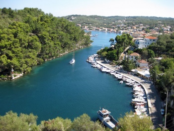
| - | | imagetext= Port Gaios looking S round ‘dogleg’ entrance | + | | imagetext= Port Gaios looking S round ‘dogleg’ entrance |
}} | }} | ||
| - | + | ||
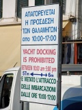
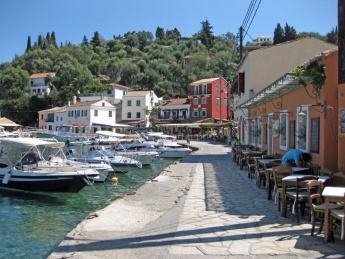
Port Gaios is the main harbour of the island of [[Paxos]] in the Ionian Sea of Greece. It lies just over half way down the NE coast of the island and consists of a long and remarkable natural inlet, protected by the island of St Nicholas immediately E of the harbour and with the addition of artificial breakwaters at its N and S ends. The town’s picturesque setting and unique geography have made it deservedly popular and during the season it is crammed full of day trippers from Corfu and the mainland and busy with yachtsmen of all nationalities, especially Italians. In spite of its bustle and sometimes frenetic atmosphere, it is usually possible to find a mooring space somewhere along its 1,000 metres and more of quays or anchored stern-to St Nicholas island itself. Note that two sections of the town quays are off limits to yachts between the hours of 1000 and 1700 in order to accommodate the tripper boats. Shelter in the harbour is excellent in most conditions, although strong SE winds make the S part of the harbour very uncomfortable. | Port Gaios is the main harbour of the island of [[Paxos]] in the Ionian Sea of Greece. It lies just over half way down the NE coast of the island and consists of a long and remarkable natural inlet, protected by the island of St Nicholas immediately E of the harbour and with the addition of artificial breakwaters at its N and S ends. The town’s picturesque setting and unique geography have made it deservedly popular and during the season it is crammed full of day trippers from Corfu and the mainland and busy with yachtsmen of all nationalities, especially Italians. In spite of its bustle and sometimes frenetic atmosphere, it is usually possible to find a mooring space somewhere along its 1,000 metres and more of quays or anchored stern-to St Nicholas island itself. Note that two sections of the town quays are off limits to yachts between the hours of 1000 and 1700 in order to accommodate the tripper boats. Shelter in the harbour is excellent in most conditions, although strong SE winds make the S part of the harbour very uncomfortable. | ||
| - | |||
| - | |||
| - | |||
| - | |||
==Charts== | ==Charts== | ||
| Line 21: | Line 21: | ||
; Greek | ; Greek | ||
: 212 Othonoi I. to Amvrakikos Gulf- Kerkyra I. And Paxoi I. Inset: Northern Kerkyra Strait | : 212 Othonoi I. to Amvrakikos Gulf- Kerkyra I. And Paxoi I. Inset: Northern Kerkyra Strait | ||
| + | |||
| + | ==Weather== | ||
| + | * ''See [[Ionian Sea#Weather_and_Winds|Ionian Sea Weather]]'' | ||
| + | * ''Also see [[Ionian Sea#Currents_&_Tides|Ionian Sea Currents & Tides]]'' | ||
==Radio Net== | ==Radio Net== | ||
| Line 29: | Line 33: | ||
''Also see [[World MM Nets|World Cruiser's Nets]]''. | ''Also see [[World MM Nets|World Cruiser's Nets]]''. | ||
| - | == | + | ==Passages== |
| + | Popular passages/routes, timing, etc. | ||
| + | * | ||
| + | |||
| + | ==Islands== | ||
| + | * [[Corfu]] | ||
| + | |||
| + | ==Navigation== | ||
There are two approaches to Port Gaios, a N approach that enters past the small island of Nisos Panayia to port and the ferry quay to starboard before turning S round a sharp dogleg into the harbour proper; and a S entrance between two short breakwaters into the main harbour itself. Most yachts favour the N approach, since depths in the S entrance are barely 2.0 – 2.5 metres and less with any swell running. The main danger in the approach from N is the frequent tripper boats leaving the harbour, especially between 1500 and 1700. The channel has a 90 degree dogleg after the first 500 metres and great care is needed when rounding the corner as the tripper boats need most of the channel to manoeuvre round. A wise skipper proceeds at around 2-3 knots and keeps well over to the starboard side of the channel at this corner. An exceptionally wise skipper also has a foghorn or whistle handy just in case. | There are two approaches to Port Gaios, a N approach that enters past the small island of Nisos Panayia to port and the ferry quay to starboard before turning S round a sharp dogleg into the harbour proper; and a S entrance between two short breakwaters into the main harbour itself. Most yachts favour the N approach, since depths in the S entrance are barely 2.0 – 2.5 metres and less with any swell running. The main danger in the approach from N is the frequent tripper boats leaving the harbour, especially between 1500 and 1700. The channel has a 90 degree dogleg after the first 500 metres and great care is needed when rounding the corner as the tripper boats need most of the channel to manoeuvre round. A wise skipper proceeds at around 2-3 knots and keeps well over to the starboard side of the channel at this corner. An exceptionally wise skipper also has a foghorn or whistle handy just in case. | ||
Depths in the channel are mostly between 3.5 and 4.0 metres, although they increase to 6.0 – 10 metres in the outer part of the N entrance channel. | Depths in the channel are mostly between 3.5 and 4.0 metres, although they increase to 6.0 – 10 metres in the outer part of the N entrance channel. | ||
| - | == | + | ==Entrance== |
| - | Gaios is a port of entry. The port office is on the W quay about 200 metres N of the main town square. | + | [[Port Gaios]] is a port of entry/exit. The port office is on the W quay about 200 metres N of the main town square. |
| + | |||
| + | ==Berthing== | ||
| - | |||
====Town Quays==== | ====Town Quays==== | ||
The town quays in Port Gaios extend for over 1,000 metres, starting on the starboard side of the N entrance just past the ferry quay (the newest section) and running along the same side of the channel all the way to the breakwaters of the S entrance. Apart from the last 150 metres between the ATE Bank building and the S entrance (which has depths of 1.5 metres or less), and a section of the W quay opposite the steps leading up St Nicholas island in the narrowest part of the channel (which is usually full of small fishing boats anyway), there are least depths of 2.5 – 3.0 metres at all the quays. The exception is the S quay in the main harbour, which has depths of just over 2.0 metres. | The town quays in Port Gaios extend for over 1,000 metres, starting on the starboard side of the N entrance just past the ferry quay (the newest section) and running along the same side of the channel all the way to the breakwaters of the S entrance. Apart from the last 150 metres between the ATE Bank building and the S entrance (which has depths of 1.5 metres or less), and a section of the W quay opposite the steps leading up St Nicholas island in the narrowest part of the channel (which is usually full of small fishing boats anyway), there are least depths of 2.5 – 3.0 metres at all the quays. The exception is the S quay in the main harbour, which has depths of just over 2.0 metres. | ||
| Line 46: | Line 58: | ||
[https://maps.google.co.uk/maps/ms?msid=210561298658189797082.0004c8df611f4f3d3bdda&msa=0]. The illustration shows the various berthing options as A: N Quay; B: W Quay; C: S Quay and D, E and F: Anchorages. Note the two sections of the quay, X and Y, reserved for tripper boats from 1000 to 1700. | [https://maps.google.co.uk/maps/ms?msid=210561298658189797082.0004c8df611f4f3d3bdda&msa=0]. The illustration shows the various berthing options as A: N Quay; B: W Quay; C: S Quay and D, E and F: Anchorages. Note the two sections of the quay, X and Y, reserved for tripper boats from 1000 to 1700. | ||
| - | {{ | + | {{Poi |39|12.13|N|20|11.21|E| | type= harbour| name= A: North Quay |
| - | | text= {{Image right|NQuayGaios.jpg |Yachts on N quay | + | | text= {{Image right|NQuayGaios.jpg |Yachts on the N quay }} |
The newest section of the harbour, this runs for 100 metres from the ferry berth in the N channel as far as the small boat moorings that then continue round the dogleg. This quay can accommodate around 20-25 yachts anchor moored stern or bows-to in depths of 2.5 metres at the quay. Depths in the channel, where yachts drop anchor, are nearer 6.0 – 8.0 metres. The holding here is good in mud and weed. }} | The newest section of the harbour, this runs for 100 metres from the ferry berth in the N channel as far as the small boat moorings that then continue round the dogleg. This quay can accommodate around 20-25 yachts anchor moored stern or bows-to in depths of 2.5 metres at the quay. Depths in the channel, where yachts drop anchor, are nearer 6.0 – 8.0 metres. The holding here is good in mud and weed. }} | ||
| - | {{hold | + | {{hold vertical}} |
| - | {{ | + | {{Poi |39|12.04|N|20|11.1|E| | type= harbour | name= B. West Quay |
| - | | text= {{Image right|WQuayGaios.jpg | | + | | text= {{Image right|WQuayGaios.jpg |Yachts on the W quay }} |
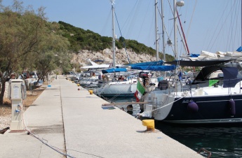
This section begins around the dogleg some 100 metres after the narrowest part of the channel, where there are only small fishing boats on laid moorings. Note that the first 50 metres (section X) is reserved from 1000 to 1700 for use by tripper boats. The second 50 metres (just N of the water taxis) can be used at any time. Some 8-10 yachts can anchor moor here in depths of 2.5 – 3.0 metres. Holding is good in mud, although it is wise not to lay out too much chain (25 metres is ample) otherwise tripper boats (and, after 1700, other yachts) using section X can lay over you. If you are unfortunate enough to be late leaving (after 1000), you may wind up having to wait until 1700 to leave if a tripper boat has laid over you. }} | This section begins around the dogleg some 100 metres after the narrowest part of the channel, where there are only small fishing boats on laid moorings. Note that the first 50 metres (section X) is reserved from 1000 to 1700 for use by tripper boats. The second 50 metres (just N of the water taxis) can be used at any time. Some 8-10 yachts can anchor moor here in depths of 2.5 – 3.0 metres. Holding is good in mud, although it is wise not to lay out too much chain (25 metres is ample) otherwise tripper boats (and, after 1700, other yachts) using section X can lay over you. If you are unfortunate enough to be late leaving (after 1000), you may wind up having to wait until 1700 to leave if a tripper boat has laid over you. }} | ||
| - | {{hold | + | {{hold vertical}} |
| - | {{ | + | {{Poi |39|11.81|N|20|11.19|E| | type= harbour | name= C. South Quay (main harbour) |
| - | | text= {{Image right|SQuayGaios.jpg |Yacht on S quay (main harbour) }} | + | | text= {{Image right|SQuayGaios.jpg |Yacht on the S quay (main harbour)}} |
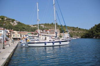
This section begins just past the town square and the water taxis and extends for the remainder of the waterfront as far as the S entrance. The last 150 metres, as mentioned above, is shallow and occupied by small fishing boats on laid moorings. Note again that the first 60 metres or so (section Y) is reserved for tripper boats from 1000 to 1700. }} | This section begins just past the town square and the water taxis and extends for the remainder of the waterfront as far as the S entrance. The last 150 metres, as mentioned above, is shallow and occupied by small fishing boats on laid moorings. Note again that the first 60 metres or so (section Y) is reserved for tripper boats from 1000 to 1700. }} | ||
| - | {{ | + | {{Poi |39|11.9|N|20|11.16|E| | type= harbour | name= D. Quay |
| - | | text= The next section of 60 metres can be used at any time. Some 12-14 boats can anchor moor here in depths of 2.0 metres. Again, it is wise not to lay out any more chain than necessary (20-25 metres) as tripper boats can lay over yachts berthed towards the N end. Holding is variable. Again, if you are unfortunate enough to be late leaving (after 1000), you may wind up having to wait until 1700 to leave if a tripper boat has laid over you. }} | + | | text= The next section of 60 metres can be used at any time. Some 12-14 boats can anchor moor here in depths of 2.0 metres. Again, it is wise not to lay out any more chain than necessary (20-25 metres) as tripper boats can lay over yachts berthed towards the N end. Holding is variable. Again, if you are unfortunate enough to be late leaving (after 1000), you may wind up having to wait until 1700 to leave if a tripper boat has laid over you.}} |
| - | {{ | + | {{hgallery| |
| - | {{ | + | {{himage|TripperGaios.jpg |Tripper boats can lay their anchors across your chain if you put out more than necessary }} |
| - | + | {{himage|SignGaios.jpg |You have been warned}} | |
| + | }} | ||
| - | === | + | ===Marinas & Yacht Clubs=== |
| - | {{Image right|AnchorGaios.jpg |Yachts anchored in N channel | + | None. |
| + | |||
| + | ==Anchorages== | ||
| + | {{Image right|AnchorGaios.jpg |Yachts anchored in the N channel }} | ||
The best anchorage is on the S side of the N channel, opposite the N quay – but being careful to avoid interfering with the anchors of yachts on the N quay (see D). Drop in 6.0 – 8.0 metres and take a line back to St Nicholas island. Alternatively, free anchor on either side of the breakwater joining St Nicholas and Panayia islands at the N entrance, depending on wind conditions (see E). Depths are 5.0 – 8.0 metres and the holding is good in sand and mud. Finally, a good anchorage in the prevailing NW winds is on the SE side of St Nicholas island, just N of the S entrance to the harbour (see F). Depths here are 6.0 – 10 metres. Good holding in sand and weed but there are several boulders and if you find yourself swinging a bit short you may well be wrapped around one. | The best anchorage is on the S side of the N channel, opposite the N quay – but being careful to avoid interfering with the anchors of yachts on the N quay (see D). Drop in 6.0 – 8.0 metres and take a line back to St Nicholas island. Alternatively, free anchor on either side of the breakwater joining St Nicholas and Panayia islands at the N entrance, depending on wind conditions (see E). Depths are 5.0 – 8.0 metres and the holding is good in sand and mud. Finally, a good anchorage in the prevailing NW winds is on the SE side of St Nicholas island, just N of the S entrance to the harbour (see F). Depths here are 6.0 – 10 metres. Good holding in sand and weed but there are several boulders and if you find yourself swinging a bit short you may well be wrapped around one. | ||
| - | |||
| - | |||
| - | == | + | ==Amenities== |
| - | + | {{tlist | |
| - | + | |header|Facilities | |
| - | + | ||
| - | + | |Water| There are now three water stanchions on the quay in the N channel and one in the W channel (four taps at each), but none in the main harbour. Payment is via a prepaid card available from the town hall or local cafes. Water is also available by mini-tanker 6974484422. | |
| - | + | |Electricity| There are now three electricity stanchions on the quay in the N channel and one in the W channel (four points at each stanchion). Payment is via a prepaid card available from the town hall or local cafes | |
| + | |Toilets| N/A (Not Available) | ||
| + | |Showers| {{MagentaText|?}} | ||
| + | |Laundry| As of July 2019 the previously mentioned Laundry Room is out of business. There is no laundry service available. | ||
| + | |Garbage| Bins at either end of the town quay, including recyclable. | ||
| - | + | |header|Supplies | |
| - | + | |Fuel| There are several mini-tankers which deliver fuel to the quay between 0800 and 1100. Tel 26620 32488 | |
| - | + | |Bottled gas| {{MagentaText|?}} | |
| - | + | |Chandlers| None | |
| - | + | ||
| - | + | ||
| - | + | ||
| - | + | |header|Services | |
| - | + | |Repairs| N/A | |
| - | + | |Internet| Most bars and cafes along the quay offer Wi-Fi | |
| - | {{ | + | |Mobile connectivity| {{MagentaText|?}} |
| - | + | |Vehicle rentals| From travel agencies along the water font | |
| - | + | }} | |
| - | + | ||
| - | == | + | ==Provisioning== |
* Two small supermarkets on the waterfront. Better one up the main street running W from the main square | * Two small supermarkets on the waterfront. Better one up the main street running W from the main square | ||
| - | * Two good bakeries in the town | + | * Two good bakeries in the town |
| - | * Excellent biscuiterie just up from NW corner of the main square next to church belltower (choc chip cookies to die for!) | + | * Excellent biscuiterie just up from NW corner of the main square next to church belltower (choc chip cookies to die for!) |
| - | == | + | ==Eating out== |
| - | * Numerous bars, cafes and tavernas along the town quay, and more in the streets immediately back from the main square | + | * Numerous bars, cafes and tavernas along the town quay, and more in the streets immediately back from the main square |
* ''Mambo Taverna'' on the S waterfront was good in September 2012 --[[User:Atheneoflymington|Athene of Lymington]] 13:57, 4 September 2012 (BST) | * ''Mambo Taverna'' on the S waterfront was good in September 2012 --[[User:Atheneoflymington|Athene of Lymington]] 13:57, 4 September 2012 (BST) | ||
| - | * ''Pan and Theo's'' on the S waterfront (next door to Mambo) is good and popular with charter crews. | + | * ''Pan and Theo's'' on the S waterfront (next door to Mambo) is good and popular with charter crews. |
| - | * For a cheap but hearty meal of gyros or chicken pitta, try ''George's Corner'' at the NW corner of the main square | + | * For a cheap but hearty meal of gyros or chicken pitta, try ''George's Corner'' at the NW corner of the main square |
| - | * ''Taka Taka'' in the back of town is quite good - rotisserie and fish | + | * ''Taka Taka'' in the back of town is quite good - rotisserie and fish |
| - | * ''Dodo's Taverna'' 80 metres up an alley next to Genesis Cafe is cute, and has great food provided by the charming owner | + | * ''Dodo's Taverna'' 80 metres up an alley next to Genesis Cafe is cute, and has great food provided by the charming owner |
| - | * ''Genesis Cafe'' is reputed to be the best in town | + | * ''Genesis Cafe'' is reputed to be the best in town |
| - | + | ||
| - | + | ||
| - | + | ||
| - | + | ==Transportation== | |
| - | + | * Hydrofoil to [[Igoumenitsa]] (mainland) and [[Corfu]] | |
| - | + | * Ferries to [[Corfu]] and [[Parga]] | |
| - | + | ||
| - | + | ||
| - | + | ||
| - | + | ||
| - | + | ||
| - | + | ||
| - | + | ||
| - | * Hydrofoil to [[Igoumenitsa]] (mainland) and [[Corfu]] | + | |
| - | * Ferries to [[Corfu]] and [[Parga]] | + | |
* Water Taxi to [[Corfu]] tel +30 693 223 2072 will pick guests up at the airport | * Water Taxi to [[Corfu]] tel +30 693 223 2072 will pick guests up at the airport | ||
| - | * The sea-plane service to [[Corfu]] appears to have been discontinued | + | * The sea-plane service to [[Corfu]] appears to have been discontinued |
| - | == | + | ==Tourism== |
| - | + | {{hold vertical}} | |
| - | + | {{Image right|SquareGaios.jpg |Main square, Port Gaios }} | |
| + | {{Image right|PaxosBeach.jpg |Typical Paxos shingle beach }} | ||
| + | {{Image right|LongosWaterfront.jpg |Longos waterfront }} | ||
| + | The main town of Gaios and the smaller villages of Lakka and Longos are very pretty, with Venetian-style architecture painted in delicate pastel colours. There is a small museum in Gaios which shelters some local artifacts (although it seems to rarely open). The island of St Nicholas that encloses the inlet of Gaios can also be visited with a permit from the town hall. It has the remains of a Venetian castle and a church on its summit as well as being a superb picnic site. Outside the town, the island’s main attraction is the numerous walks through its shady pine and olive groves. The [http://odysseus.culture.gr/h/2/eh251.jsp?obj_id=732 Windmill of Paxos Island] is also worth a visit. On the W side of Paxos there are several caves which can be visited in settled weather. Boat trips run throughout the day, which are probably a safer bet than taking your own boat. Finally, there are several small but charming shingle beaches off the road heading N from Port Gaios towards Longos which can be visited on foot or with a bicycle. | ||
| - | == | + | ==Friends== |
Contact details of "Cruiser's Friends" that can be contacted for local information or assistance. | Contact details of "Cruiser's Friends" that can be contacted for local information or assistance. | ||
* | * | ||
| - | == | + | ==Forums== |
List links to discussion threads on [[Cruising Forums|partnering forums]]. (see link for requirements) | List links to discussion threads on [[Cruising Forums|partnering forums]]. (see link for requirements) | ||
* | * | ||
* | * | ||
| - | == | + | ==Links== |
| - | * | + | * {{Wikipedia|Gaios}} |
* | * | ||
| - | ==References | + | ==References== |
''See [[Ionian Sea#References_&_Publications|Ionian Sea]]''. | ''See [[Ionian Sea#References_&_Publications|Ionian Sea]]''. | ||
| - | + | {{Comments}} | |
| - | + | ||
* A beautiful island. Take a bit of time and bicycle about. --[[User:Monterey|Monterey]] June 2011 | * A beautiful island. Take a bit of time and bicycle about. --[[User:Monterey|Monterey]] June 2011 | ||
* While initially the mooring routine may seem confusing, once you get the hang of it is usually easy finding a berth in Port Gaios unless you arrive late during high season. Be sure not to leave valuables on view from the quay - petty thefts are not unknown here. --[[User:Atheneoflymington|Athene of Lymington]] 13:55, 4 September 2012 (BST) | * While initially the mooring routine may seem confusing, once you get the hang of it is usually easy finding a berth in Port Gaios unless you arrive late during high season. Be sure not to leave valuables on view from the quay - petty thefts are not unknown here. --[[User:Atheneoflymington|Athene of Lymington]] 13:55, 4 September 2012 (BST) | ||
| Line 159: | Line 162: | ||
* | * | ||
| - | + | {{Verified by}} | |
| - | + | ||
* July 1988 {{Istioploos2}} | * July 1988 {{Istioploos2}} | ||
* August 2009 -- [[User:Nereus|Nereus]] | * August 2009 -- [[User:Nereus|Nereus]] | ||
| Line 175: | Line 177: | ||
{{Contributors|[[User:Istioploos|Istioploos]], [[User:Nereus|Nereus]], [[User:Lukescully|Lukescully]], [[User:Wayward|Wayward]], [[User:Atheneoflymington|Athene of Lymington]], [[User:Monterey|Monterey]]}} | {{Contributors|[[User:Istioploos|Istioploos]], [[User:Nereus|Nereus]], [[User:Lukescully|Lukescully]], [[User:Wayward|Wayward]], [[User:Atheneoflymington|Athene of Lymington]], [[User:Monterey|Monterey]]}} | ||
| - | + | [[Category:Ports - Greece]] | |
| - | + | ||
| - | [[Category:Ports | + | |
Latest revision as of 15:48, 5 July 2019
| Port Gaios Port of Entry
| |
| | |
Port Gaios is the main harbour of the island of Paxos in the Ionian Sea of Greece. It lies just over half way down the NE coast of the island and consists of a long and remarkable natural inlet, protected by the island of St Nicholas immediately E of the harbour and with the addition of artificial breakwaters at its N and S ends. The town’s picturesque setting and unique geography have made it deservedly popular and during the season it is crammed full of day trippers from Corfu and the mainland and busy with yachtsmen of all nationalities, especially Italians. In spite of its bustle and sometimes frenetic atmosphere, it is usually possible to find a mooring space somewhere along its 1,000 metres and more of quays or anchored stern-to St Nicholas island itself. Note that two sections of the town quays are off limits to yachts between the hours of 1000 and 1700 in order to accommodate the tripper boats. Shelter in the harbour is excellent in most conditions, although strong SE winds make the S part of the harbour very uncomfortable.
Charts
- BA
- 189 Nisos Sapiénza to Nisos Paxoi
- 203 Zakinthos to Paxoi
- Imray-Tetra
- G11 Nísos Kérkira to Nísos Levkas
- NIMA
- 54280 Corfu Channel to Nisis Proti
- Greek
- 212 Othonoi I. to Amvrakikos Gulf- Kerkyra I. And Paxoi I. Inset: Northern Kerkyra Strait
Weather
- See Ionian Sea Weather
- Also see Ionian Sea Currents & Tides
Radio Net
- Coast Guard - VHF channel 12
- Olympia Radio - VHF channel 03
Also see World Cruiser's Nets.
Passages
Popular passages/routes, timing, etc.
Islands
There are two approaches to Port Gaios, a N approach that enters past the small island of Nisos Panayia to port and the ferry quay to starboard before turning S round a sharp dogleg into the harbour proper; and a S entrance between two short breakwaters into the main harbour itself. Most yachts favour the N approach, since depths in the S entrance are barely 2.0 – 2.5 metres and less with any swell running. The main danger in the approach from N is the frequent tripper boats leaving the harbour, especially between 1500 and 1700. The channel has a 90 degree dogleg after the first 500 metres and great care is needed when rounding the corner as the tripper boats need most of the channel to manoeuvre round. A wise skipper proceeds at around 2-3 knots and keeps well over to the starboard side of the channel at this corner. An exceptionally wise skipper also has a foghorn or whistle handy just in case.
Depths in the channel are mostly between 3.5 and 4.0 metres, although they increase to 6.0 – 10 metres in the outer part of the N entrance channel.
Entrance
Port Gaios is a port of entry/exit. The port office is on the W quay about 200 metres N of the main town square.
Berthing
Town Quays
The town quays in Port Gaios extend for over 1,000 metres, starting on the starboard side of the N entrance just past the ferry quay (the newest section) and running along the same side of the channel all the way to the breakwaters of the S entrance. Apart from the last 150 metres between the ATE Bank building and the S entrance (which has depths of 1.5 metres or less), and a section of the W quay opposite the steps leading up St Nicholas island in the narrowest part of the channel (which is usually full of small fishing boats anyway), there are least depths of 2.5 – 3.0 metres at all the quays. The exception is the S quay in the main harbour, which has depths of just over 2.0 metres.
A daily charge, collected by port police staff every evening, is made on all the quays. In 2012 this equated to around Euros 1.50 per metre per night. In addition, an electronic key to obtain water and electricity can be obtained from the Deep Blue café on the W quay or the port police office 100 metres further N. A returnable deposit of Euros 10 is required for the key, which is then loaded with Euros 8 for use in the water and electricity stanchions.
Click on this link for a map of the various berthing options in Port Gaios: [1]. The illustration shows the various berthing options as A: N Quay; B: W Quay; C: S Quay and D, E and F: Anchorages. Note the two sections of the quay, X and Y, reserved for tripper boats from 1000 to 1700.
A: North Quay
B. West Quay
C. South Quay (main harbour)
D. Quay
Marinas & Yacht Clubs
None.
Anchorages
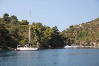
The best anchorage is on the S side of the N channel, opposite the N quay – but being careful to avoid interfering with the anchors of yachts on the N quay (see D). Drop in 6.0 – 8.0 metres and take a line back to St Nicholas island. Alternatively, free anchor on either side of the breakwater joining St Nicholas and Panayia islands at the N entrance, depending on wind conditions (see E). Depths are 5.0 – 8.0 metres and the holding is good in sand and mud. Finally, a good anchorage in the prevailing NW winds is on the SE side of St Nicholas island, just N of the S entrance to the harbour (see F). Depths here are 6.0 – 10 metres. Good holding in sand and weed but there are several boulders and if you find yourself swinging a bit short you may well be wrapped around one.
Amenities
| Facilities | |
|---|---|
| Water | There are now three water stanchions on the quay in the N channel and one in the W channel (four taps at each), but none in the main harbour. Payment is via a prepaid card available from the town hall or local cafes. Water is also available by mini-tanker 6974484422. |
| Electricity | There are now three electricity stanchions on the quay in the N channel and one in the W channel (four points at each stanchion). Payment is via a prepaid card available from the town hall or local cafes |
| Toilets | N/A (Not Available) |
| Showers | ? |
| Laundry | As of July 2019 the previously mentioned Laundry Room is out of business. There is no laundry service available. |
| Garbage | Bins at either end of the town quay, including recyclable. |
| Supplies | |
| Fuel | There are several mini-tankers which deliver fuel to the quay between 0800 and 1100. Tel 26620 32488 |
| Bottled gas | ? |
| Chandlers | None |
| Services | |
| Repairs | N/A |
| Internet | Most bars and cafes along the quay offer Wi-Fi |
| Mobile connectivity | ? |
| Vehicle rentals | From travel agencies along the water font |
Provisioning
- Two small supermarkets on the waterfront. Better one up the main street running W from the main square
- Two good bakeries in the town
- Excellent biscuiterie just up from NW corner of the main square next to church belltower (choc chip cookies to die for!)
Eating out
- Numerous bars, cafes and tavernas along the town quay, and more in the streets immediately back from the main square
- Mambo Taverna on the S waterfront was good in September 2012 --Athene of Lymington 13:57, 4 September 2012 (BST)
- Pan and Theo's on the S waterfront (next door to Mambo) is good and popular with charter crews.
- For a cheap but hearty meal of gyros or chicken pitta, try George's Corner at the NW corner of the main square
- Taka Taka in the back of town is quite good - rotisserie and fish
- Dodo's Taverna 80 metres up an alley next to Genesis Cafe is cute, and has great food provided by the charming owner
- Genesis Cafe is reputed to be the best in town
Transportation
- Hydrofoil to Igoumenitsa (mainland) and Corfu
- Ferries to Corfu and Parga
- Water Taxi to Corfu tel +30 693 223 2072 will pick guests up at the airport
- The sea-plane service to Corfu appears to have been discontinued
Tourism
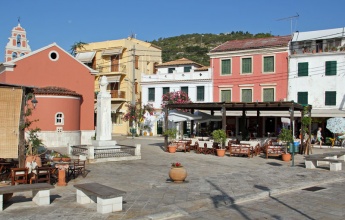
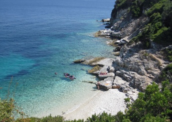
The main town of Gaios and the smaller villages of Lakka and Longos are very pretty, with Venetian-style architecture painted in delicate pastel colours. There is a small museum in Gaios which shelters some local artifacts (although it seems to rarely open). The island of St Nicholas that encloses the inlet of Gaios can also be visited with a permit from the town hall. It has the remains of a Venetian castle and a church on its summit as well as being a superb picnic site. Outside the town, the island’s main attraction is the numerous walks through its shady pine and olive groves. The Windmill of Paxos Island is also worth a visit. On the W side of Paxos there are several caves which can be visited in settled weather. Boat trips run throughout the day, which are probably a safer bet than taking your own boat. Finally, there are several small but charming shingle beaches off the road heading N from Port Gaios towards Longos which can be visited on foot or with a bicycle.
Friends
Contact details of "Cruiser's Friends" that can be contacted for local information or assistance.
Forums
List links to discussion threads on partnering forums. (see link for requirements)
Links
- Port Gaios at the Wikipedia
References
See Ionian Sea.
Comments
We welcome users' contributions to the Wiki. Please click on Comments to view other users' comments, add your own personal experiences or recommend any changes to this page following your visit.
- A beautiful island. Take a bit of time and bicycle about. --Monterey June 2011
- While initially the mooring routine may seem confusing, once you get the hang of it is usually easy finding a berth in Port Gaios unless you arrive late during high season. Be sure not to leave valuables on view from the quay - petty thefts are not unknown here. --Athene of Lymington 13:55, 4 September 2012 (BST)
- In September 2013 we were charged €30 for 14.9m. In October, there was no charge --Zebahdy of London
Verified by
Date of member's last visit to Port Gaios and this page's details validated:
- July 1988 --Istioploos

 Travels with S/Y Thetis
- August 2009 -- Nereus
- Some amendments and additions August 2011 --Wayward

- September 2012 --Athene of Lymington 17:47, 4 September 2012 (BST)
- September 2013 --Zebahdy of London
- Sept 2014 --Monterey

| This is a usable page of the cruising guide. However, please contribute if you can to help it grow further. Click on Comments to add your personal notes on this page or to discuss its contents. Alternatively, if you feel confident to edit the page, click on the edit tab at the top and enter your changes directly. |
| |
|---|
|
Names: Istioploos, Nereus, Lukescully, Wayward, Athene of Lymington, Monterey |
