Ravni Žakan and Kameni Žakan
From CruisersWiki
Istioploos (Talk | contribs) m (→Kameni Zakan: Typo) |
Istioploos (Talk | contribs) (Template) |
||
| (30 intermediate revisions not shown) | |||
| Line 1: | Line 1: | ||
| - | + | {{IsPartOf|Mediterranean|Adriatic Sea|Croatia|Northern Dalmatia|Kornati archipelago}} | |
| + | {{TOC block}} | ||
| - | {{Infobox | | + | {{Infobox |
| - | | | + | | lat= 43.72265|lon=15.43653 |
| - | | | + | | name= Ravni Žakan and Kameni Žakan |
| - | | | + | | portofentry= |
| - | + | | containsportofentry= | |
| - | + | | zoom= 14 | |
| - | | | + | | chartlet = y |
| - | | | + | | image= |
| - | |} | + | | imagetext= {{Magenta|Map or Picture of Island}} |
| - | + | | summary= The islands of [[Ravni Žakan and Kameni Žakan]] are lying off the SE tip of the island of [[Kornat]] in the [[Kornati archipelago]] group of [[Croatia]]. The two islands are separated from [[Kornat]] by the mile-wide channel of the '''Kornatski Kanal'''. Two miles to the E is the island of [[Vela Smokvica]] with a further anchorage. '''Ravni Žakan''' offers two anchorages, offering good shelter in N and S winds respectively, whereas '''Kameni Žakan''' has just one settled weather anchorage off its W coast. As part of the [http://www.np-kornati.hr/en Kornati National Park], a daily permit is required to visit the islands. Ashore, there is a visitor centre of the Kornati National Park and two restaurants on '''Ravni Žakan''' but no facilities on '''Kameni Žakan'''. Both islands are largely uninhabited except for the restaurant and national park staff during the season. | |
| + | | notes= | ||
| + | | news= | ||
| + | }} | ||
==Charts== | ==Charts== | ||
| - | + | ''See [[Northern Dalmatia#Charts|Northern Dalmatia]]''. | |
| - | + | ||
| - | + | ||
| - | + | ||
| - | + | ||
| - | + | ||
| - | == | + | ==Weather== |
| - | + | ''See [[Croatia#Weather|Croatia]]''. | |
| - | + | ||
| - | '' | + | ==Passages== |
| + | ''See [[Croatia#Passages|Croatia]]''. | ||
| - | == | + | ==Islands== |
| - | + | * [[Kornat]] | |
| + | * [[Vela Smokvica]] | ||
| + | |||
| + | ==Communication== | ||
| + | {{Green|Add here VHF channel for coastguard, harbor masters. etc.}} | ||
| + | * | ||
| + | * | ||
| - | + | ''Also see [[World MM Nets|World Cruiser's Nets]]'' | |
| - | + | ==Navigation== | |
| + | {{Green|Add any navigation notes such approaches, dangers etc here. If this section does not apply, remove it.}} | ||
| - | == | + | ==Entrance== |
| - | [[Zadar]] and [[ | + | [[Zadar]] and [[Šibenik]] are the nearest all-year ports of entry. In summer only, [[Božava]] and [[Sali]] on [[Dugi Otok]] are also ports of entry. |
| - | ==Berthing | + | ==Berthing== |
| - | There are three berthing options on Ravni | + | There are three berthing options on '''Ravni Žakan''' Island, on the N and S sides of the island, plus a third option just W of the island of''' Kameni Zanak''', in the channel between it and the islet of Jančar. |
===Ports=== | ===Ports=== | ||
| Line 43: | Line 49: | ||
===Marinas & Yacht Clubs=== | ===Marinas & Yacht Clubs=== | ||
| - | None, but | + | None, but [[Marina Piškera]] lies five miles to the NW. |
| - | + | ==Anchorages== | |
| - | ====Ravni | + | {{Poi | lat= 43.72569|lon=15.43219 | type= buoy |
| - | + | | name= Ravni Žakan S | |
| - | + | | altname= | |
| - | + | | zoom= 18 | |
| + | | image= RavniZakanRestaurant.jpg | ||
| + | | imagetext= The restaurant pier on Ravni Žakan | ||
| + | | imagewidth= | ||
| + | | text= This anchorage is on the S side of the island, protected to some extent by the islets of [[#Kameni Žakan|Kameni Žakan]] and '''Jančar''' a few hundred meters to the S. Shelter in the bay is good in all conditions except strong S winds. | ||
| - | + | There are no dangers in the approach, although in the approach from the S {{mark|type=danger|name=beware of the reefs|lat=43.71268|lon=15.44322|zoom=16}} half a mile SW of '''Kameni Žakan'''. | |
| - | {{ | + | |
| - | + | ||
| - | + | Depths in the outer part of the anchorage are 12 metres, shoaling gradually towards the head to around 4.0 metres. | |
| - | + | ||
| - | + | ||
| - | + | At the head of the bay is the Restaurant ''Ravni Žakan'', which has a jetty with laid moorings and recently installed water and electricity on the jetty. The jetty is very busy in summer. | |
| - | + | ||
| - | + | ||
| - | + | There are also some (free) mooring buoys in the bay which can be picked up if you do not wish to eat in the restaurant. Finally, it is possible to free anchor in 9.0 - 10.0 metres. The holding is good in sand and weed. | |
| - | + | ||
| - | + | Also ashore here is a visitors centre for the [http://www.np-kornati.hr/en Kornati National Park] where daily permits can be purchased if you have not already done so prior to arrival. | |
| - | + | }} | |
| - | ==== | + | {{Poi |lat= 43.727868032092275| lon= 15.43149033167499 | type= anchorage |
| - | + | | name= Ravni Žakan N | |
| + | | zoom= 18 | ||
| + | | image= | ||
| + | | imagetext= | ||
| + | | imagewidth= | ||
| + | | text= This anchorage is on the N side of the island, separated from the S anchorage by a low isthmus. | ||
| - | + | This anchorage offers better protection than the other in southerly winds, but is completely opento the NW and, to some extent, to the W. Anchor in 8.0 - 10.0 metres, with a line ashore if possible. The holding is good in sand. There is a restaurant ashore during the season. | |
| - | + | }} | |
| - | + | ||
| - | ==== | + | {{Poi |lat= 43.7196686154188| lon= 15.43448845893574 |
| - | + | | type= anchorage | |
| + | | name= Kameni Žakan | ||
| + | | zoom= 17 | ||
| + | | image= KameniZakanAnchorage.jpg | ||
| + | | imagetext= The anchorage of Kameni Žakan | ||
| + | | imagewidth= | ||
| + | | text= The anchorage is situated half a mile S of '''Ravni Žakan''', in the channel between [[Kameni Žakan]] and the adjacent islet of '''Jančar'''. The anchorage here is best in settled weather, since it is exposed to an extent to winds from all directions except from the E. Anchor in 4.0 - 5.0 metres in the channel. The holding is good in sand. | ||
| + | }} | ||
| - | == | + | ==Amenities== |
| - | + | {{tlist | |
| - | + | |header|Facilities | |
| - | + | ||
| - | + | |Water| N/A (Not Available). | |
| - | {{MagentaText|?}} | + | |Electricity| N/A |
| + | |Toilets| {{MagentaText|?}} | ||
| + | |Showers| {{MagentaText|?}} | ||
| + | |Laundry| N/A | ||
| + | |Garbage| Bins in the coves | ||
| - | == | + | |header|Supplies |
| + | |Fuel| N/A | ||
| + | |Bottled gas| None | ||
| + | |Chandlers| None | ||
| + | |||
| + | |header|Services | ||
| + | |Repairs| N/A | ||
| + | |Internet| N/A (Not Available) | ||
| + | |Mobile connectivity| {{Green|Is there mobile telephone signal such as G4, G3, GPRS on the island? How strong is the signal? Are there any blind spots?}} | ||
| + | |Vehicle rentals| N/A | ||
| + | }} | ||
| + | |||
| + | ==Provisioning== | ||
None. | None. | ||
| - | == | + | ==Eating out== |
| - | + | {{mark |name= Ravni Žakan | type= eatingout |text=restaurant in [[#Ravni Žakan S|Ravni Žakan S]].}} | |
| + | |||
| + | {{mark |name= In [[#Ravni Žakan N|Ravni Žakan N]] | type= eatingout |text=restaurant.}} | ||
| + | |||
| + | ==Transportation== | ||
| + | N/A. | ||
| + | |||
| + | ==Tourism== | ||
| + | There are no permanent settlements on either of the '''Žakan islands''', the few cottages being occupied seasonally by fishermen or other owners from the mainland or adjoining islands. Most of the summer residents consist of the restaurant owners, the national park staff and their families. There are no restrictions on walking ashore but bear in mind that most of the land is private property. | ||
| - | == | + | ==Friends== |
Contact details of "Cruiser's Friends" that can be contacted for local information or assistance. | Contact details of "Cruiser's Friends" that can be contacted for local information or assistance. | ||
* | * | ||
| - | == | + | ==Forums== |
List links to discussion threads on [[Cruising Forums|partnering forums]]. (''see link for requirements'') | List links to discussion threads on [[Cruising Forums|partnering forums]]. (''see link for requirements'') | ||
* [http://www.cruisersforum.com/forums/tags/croatia.html Croatia Sailing and Cruising Discussions on Cruisers Forum] | * [http://www.cruisersforum.com/forums/tags/croatia.html Croatia Sailing and Cruising Discussions on Cruisers Forum] | ||
* | * | ||
| - | == | + | ==Links== |
* [http://kornati.hr/eng/ Kornati National Park] | * [http://kornati.hr/eng/ Kornati National Park] | ||
* [http://www.about-croatia.com/croatia-marina.php List of all Croatian marinas] | * [http://www.about-croatia.com/croatia-marina.php List of all Croatian marinas] | ||
| - | |||
* [http://croatia.hr/en-GB/Homepage Croatian National Tourist Board] | * [http://croatia.hr/en-GB/Homepage Croatian National Tourist Board] | ||
* [http://www.find-croatia.com Find Croatia travel guide] | * [http://www.find-croatia.com Find Croatia travel guide] | ||
* [http://en.wikipedia.org/wiki/Croatia Wikipedia - Croatia] | * [http://en.wikipedia.org/wiki/Croatia Wikipedia - Croatia] | ||
| - | ==References | + | ==References== |
| - | ''See [[Croatia#References | + | ''See [[Croatia#References|Croatia]]''. |
| - | + | {{Comments}} | |
| - | + | * | |
* | * | ||
| - | + | {{Verified by}} | |
| - | + | ||
* July 2005 --[[User:Atheneoflymington|Athene of Lymington]] 16:20, 15 November 2012 (GMT) | * July 2005 --[[User:Atheneoflymington|Athene of Lymington]] 16:20, 15 November 2012 (GMT) | ||
* | * | ||
| Line 128: | Line 163: | ||
{{Contributors|[[User:Atheneoflymington|Athene of Lymington]]}} | {{Contributors|[[User:Atheneoflymington|Athene of Lymington]]}} | ||
| - | |||
| - | |||
[[Category:Islands - Croatia]] [[Category:Anchorages - Croatia]] | [[Category:Islands - Croatia]] [[Category:Anchorages - Croatia]] | ||
Latest revision as of 22:01, 26 March 2019
| Ravni Žakan and Kameni Žakan
| |
|
The islands of Ravni Žakan and Kameni Žakan are lying off the SE tip of the island of Kornat in the Kornati archipelago group of Croatia. The two islands are separated from Kornat by the mile-wide channel of the Kornatski Kanal. Two miles to the E is the island of Vela Smokvica with a further anchorage. Ravni Žakan offers two anchorages, offering good shelter in N and S winds respectively, whereas Kameni Žakan has just one settled weather anchorage off its W coast. As part of the Kornati National Park, a daily permit is required to visit the islands. Ashore, there is a visitor centre of the Kornati National Park and two restaurants on Ravni Žakan but no facilities on Kameni Žakan. Both islands are largely uninhabited except for the restaurant and national park staff during the season.
Charts
See Northern Dalmatia.
Weather
See Croatia.
Passages
See Croatia.
Islands
Communication
Add here VHF channel for coastguard, harbor masters. etc.
Also see World Cruiser's Nets
Add any navigation notes such approaches, dangers etc here. If this section does not apply, remove it.
Entrance
Zadar and Šibenik are the nearest all-year ports of entry. In summer only, Božava and Sali on Dugi Otok are also ports of entry.
Berthing
There are three berthing options on Ravni Žakan Island, on the N and S sides of the island, plus a third option just W of the island of Kameni Zanak, in the channel between it and the islet of Jančar.
Ports
None.
Marinas & Yacht Clubs
None, but Marina Piškera lies five miles to the NW.
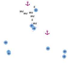
Anchorages

Ravni Žakan S
This anchorage is on the S side of the island, protected to some extent by the islets of Kameni Žakan and Jančar a few hundred meters to the S. Shelter in the bay is good in all conditions except strong S winds.
There are no dangers in the approach, although in the approach from the S ![]() beware of the reefs [[Ravni Žakan and Kameni Žakan#beware of the reefs|beware of the reefs]] 43°42.761'N, 015°26.593'E half a mile SW of Kameni Žakan.
beware of the reefs [[Ravni Žakan and Kameni Žakan#beware of the reefs|beware of the reefs]] 43°42.761'N, 015°26.593'E half a mile SW of Kameni Žakan.
Depths in the outer part of the anchorage are 12 metres, shoaling gradually towards the head to around 4.0 metres.
At the head of the bay is the Restaurant Ravni Žakan, which has a jetty with laid moorings and recently installed water and electricity on the jetty. The jetty is very busy in summer.
There are also some (free) mooring buoys in the bay which can be picked up if you do not wish to eat in the restaurant. Finally, it is possible to free anchor in 9.0 - 10.0 metres. The holding is good in sand and weed.
Also ashore here is a visitors centre for the Kornati National Park where daily permits can be purchased if you have not already done so prior to arrival.Ravni Žakan N
This anchorage is on the N side of the island, separated from the S anchorage by a low isthmus.
This anchorage offers better protection than the other in southerly winds, but is completely opento the NW and, to some extent, to the W. Anchor in 8.0 - 10.0 metres, with a line ashore if possible. The holding is good in sand. There is a restaurant ashore during the season.
Kameni Žakan
Amenities
| Facilities | |
|---|---|
| Water | N/A (Not Available). |
| Electricity | N/A |
| Toilets | ? |
| Showers | ? |
| Laundry | N/A |
| Garbage | Bins in the coves |
| Supplies | |
| Fuel | N/A |
| Bottled gas | None |
| Chandlers | None |
| Services | |
| Repairs | N/A |
| Internet | N/A (Not Available) |
| Mobile connectivity | Is there mobile telephone signal such as G4, G3, GPRS on the island? How strong is the signal? Are there any blind spots? |
| Vehicle rentals | N/A |
Provisioning
None.
Eating out
![]() Ravni Žakan [[Ravni Žakan and Kameni Žakan#Ravni Žakan|Ravni Žakan]] restaurant in Ravni Žakan S.
Ravni Žakan [[Ravni Žakan and Kameni Žakan#Ravni Žakan|Ravni Žakan]] restaurant in Ravni Žakan S.
![]() In Ravni Žakan N [[Ravni Žakan and Kameni Žakan#In Ravni Žakan N|In Ravni Žakan N]] restaurant.
In Ravni Žakan N [[Ravni Žakan and Kameni Žakan#In Ravni Žakan N|In Ravni Žakan N]] restaurant.
Transportation
N/A.
Tourism
There are no permanent settlements on either of the Žakan islands, the few cottages being occupied seasonally by fishermen or other owners from the mainland or adjoining islands. Most of the summer residents consist of the restaurant owners, the national park staff and their families. There are no restrictions on walking ashore but bear in mind that most of the land is private property.
Friends
Contact details of "Cruiser's Friends" that can be contacted for local information or assistance.
Forums
List links to discussion threads on partnering forums. (see link for requirements)
Links
- Kornati National Park
- List of all Croatian marinas
- Croatian National Tourist Board
- Find Croatia travel guide
- Wikipedia - Croatia
References
See Croatia.
Comments
We welcome users' contributions to the Wiki. Please click on Comments to view other users' comments, add your own personal experiences or recommend any changes to this page following your visit.
Verified by
Date of member's last visit to Ravni Žakan and Kameni Žakan and this page's details validated:
- July 2005 --Athene of Lymington 16:20, 15 November 2012 (GMT)
| This is a usable page of the cruising guide. However, please contribute if you can to help it grow further. Click on Comments to add your personal notes on this page or to discuss its contents. Alternatively, if you feel confident to edit the page, click on the edit tab at the top and enter your changes directly. |
| |
|---|
|
Names: Athene of Lymington |