Tanzania
From CruisersWiki
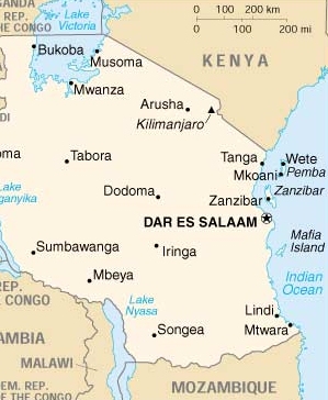
Tanzania, officially the United Republic of Tanzania (Swahili: Jamhuri ya Muungano wa Tanzania), is a country in East Africa bordered by Kenya and Uganda on the north, Rwanda, Burundi and the Democratic Republic of the Congo on the west, and Zambia, Malawi and Mozambique on the south. To the east it borders the Indian Ocean.
The country's name is a portmanteau of Tanganyika, which is the large mainland territory, and Zanzibar, the offshore archipelago. The two former British colonies united in 1964, forming the United Republic of Tanganyika and Zanzibar, which later the same year was renamed the United Republic of Tanzania.
At 364,875 mi² (945,087 km²), Tanzania is the world's 31st-largest country (it comes after Egypt). It is comparable in size to Nigeria, and is slightly more than twice the size of the U.S. state of California.
Tanzania is mountainous in the northeast, where Mount Kilimanjaro, Africa's highest peak, is situated. To the north and west are the Great Lakes of Lake Victoria (Africa's largest lake) and Lake Tanganyika (Africa's deepest lake, known for its unique species of fish). Central Tanzania comprises a large plateau, with plains and arable land. The eastern shore is hot and humid, with the island of Zanzibar lying just offshore.
Tanzania contains many large and ecologically significant wildlife parks, including the famous Ngorongoro Crater, Serengeti National Park in the north, and Selous Game Reserve and Mikumi National Park in the south. Gombe National Park in the west is known as the site of Dr. Jane Goodall's studies of chimpanzee behavior.
Charts
British Admiralty
- BA661 - Approaches to Kilwa Kisiswani harbour
- BA1032 - North Mafia channel to Kilwa point
- BA2110 - North entrance to Mozambique Channel
- BA2951 - Cabo Delgado to Lamu bay
- BA3308 - Cabo Delgado to Fanjove island
- BA3309 - Fanjove island to Dar es Salaam
- BA3310 - Dar es Salaam to Wasin island
- Source
- Chart Number - Chart Name
Weather
The weather varies greatly within Tanzania. In the highlands, temperatures range between 10 and 20 °C (50 and 68 °F) during cold and hot seasons respectively. The rest of the country has temperatures rarely falling lower than 20 °C (68 °F). The hottest period extends between November and February (25–31 °C or 77.0–87.8 °F) while the coldest period occurs between May and August (15–20 °C or 59–68 °F). Annual temperature is 20 °C (68.0 °F). The climate is cool in high mountainous regions.
Tanzania has two major rainfall regimes: one is uni-modal (October–April) and the other is bi-modal (October–December and March–May). The former is experienced in southern, central, and western parts of the country, and the latter is found in the north from Lake Victoria extending east to the coast. The bi-modal regime is caused by the seasonal migration of the Intertropical Convergence Zone.
Weather links
Passages
See Mozambique Channel.
Islands
- Zanzibar |
 – harbour |
- Azam Zanzibar Marina |
 – marina |
-
Communication
Add here VHF channel for coastguard, harbor masters. etc.
Also see World Cruiser's Nets
Add any navigation notes such approaches, dangers etc here. If this section does not apply remove it.
Entrance
Arrival
Details?
Departure
Details?
Customs and Immigration
Customs
Details?
Immigration
Details?
Health
Health
Submit any health warnings/information. Remove any of these sections do not apply to this particular country.
Security
Details?
Berthing
| Ports, Marinas, & Anchorages | |||
|
|
|
|
Transportation
- There are two major airports; one in Dar es Salaam, Julius Nyerere International Airport (DAR IATA) (formerly known as Mwalimu Julius K. Nyerere International Airport and Dar es Salaam International Airport), and one in Kilimanjaro, Kilimanjaro International Airport (JRO IATA) , which is halfway between Arusha and Moshi
- The Tanzania - Zambia train service, known as TAZARA, operates trains twice a week between New Kapiri Mposhi, Zambia, and Dar es Salaam, leaving from Dar es Salaam on Tuesdays and Fridays
- The bus is a great way to get into Tanzania
- Azam Marine and Fast Ferries connect Dar es Salaam and Zanzibar. It's about 90 minutes sailing
Friends
Submit details/contacts of cruiser's "friends" that can be contacted in advance or on arrival - who can offer information and assistance to our cruising "family".
Forums
List links to discussion threads on partnering forums. (see link for requirements)
Links
References
- Delwyn McPhun, East Africa Pilot, Imray, Laurie, Norie & Wilson Ltd (December 1, 1996), ISBN 978-0852882511
Comments
We welcome users' contributions to the Wiki. Please click on Comments to view other users' comments, add your own personal experiences or recommend any changes to this page following your visit.
Verified by
Date of member's last visit to Tanzania and this page's details validated:
- Compiled from research (pilot books, internet, etc.) February, 2019 --Istioploos

 Travels with S/Y Thetis
If you provide a lot of info and this page is almost complete, change {{Page outline}} to {{Page useable}}.
| This page has an outline in place but needs completing. Please contribute if you can to help it grow further. Click on Comments to suggest further content or alternatively, if you feel confident to edit this page, click on the edit tab at the top and enter your changes directly. |
| |
|---|
|
Names: Lighthouse, Istioploos |

