Tyne River
From CruisersWiki
| Tyne River
| |
| | |
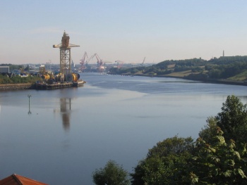
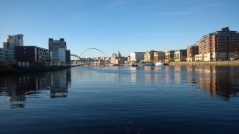
The River Tyne flows through Newcastle-Upon-Tyne which is 9nm from the sea. The river has a maintained depth of 4.5 meters as far as Newcastle Quayside and the City Marina. The Millennium (foot) bridge lies towards the east end of Newcastle Quayside and allows an air draught of 4.5 meters in it's normal position but this increases to 25 meters when tilted. There are three marinas on the river as well as trot moorings at various points along the river banks and a couple of anchorages immediately inside the harbor walls. The river flows rapidly in strong tides, reaching 3 knots on the ebb around the quayside and 2.5 knots on the flood.
The relevant authority for the navigable parts of the River Tyne is The Port of Tyne
Charts
- British Admiralty
- Chart 1934 - River Tyne
Weather
The River Tyne is on the East coast of England and therefore winds with some westerly component usually give rise to the best sailing conditions at sea. The river itself is sheltered however strong northerly or easterly winds can produce rough conditions and make the harbour entrance dangerous.
Sources for weather reports:
- Inshore Forecast for Berwick Upon Tweed to Whitby
- Shipping Forecast for Tyne
- Costal Forecast for Berwick Upon Tweed to Whitby
- VHF: The coastguard broadcasts a forecast approximately every 4 hours after first announcing the channel to use on VHF 16
Passages
All distances are given from the river mouth between the piers
Within the river
- 2.1nm to Royal Quays Marina
- 7.9nm to St. Peters Marina
- 9.0nm to the Millennium Bridge
- 9.1nm to Newcastle City Marina
Distances to ports further north
- 7nm to Blyth
- 20nm to Amble
- 43nm to Holy Island
Distances to ports further south
- 6nm to Sunderland
- 11nm to Seaham
- 22nm to Hartlepool
- 42nm to Whitby
- 57nm to Scarborough
- 117nm to Grimsby
- 193nm to Lowestoft
Communication
- VHF Channel 12 - Tyne VTS - Phone : +44 191 257 2080
- VHF Channel 80 - Royal Quays Marina
Also see World Cruiser's Nets.
The entrance to the River Tyne is well marked lit. There is a light house with characteristics Fl(3) 10s 26m 26M on the north pier and once inside the piers the channel has port starboard lateral markers for the first nautical mile to the fish quay.
The following cautions should be noted
- Strong tides can flow across the entrance
- In bad weather the piers can create a very confused sea
- When heading downstream care must be taken to pass to the south of the starboard lateral marker on Bill Point (near the Newcastle Offshore Technology Park) as it marks a shallow area extending south from the north bank.
All vessels under 20m LOA should keep a listening watch for Tyne VTS on VHF Channel 12 and are requested to report in to Tyne VTS on VHF channel 12 as follows:
- When nearing the pier heads e.g. "Tyne VTS this is your vessel name piers to Royal Quays over"
- On leaving a marina to head for the sea e.g. "Tyne VTS this is your vessel name Royal Quays to sea over"
The Port of Tyne publishes Navigational Notices which can also be obtained via email or an rss feed.
Berthing
See below for Marinas & Clubs. In addition it may be possible to arrange to stay on the private pontoon just before the millennium bridge. Contact River Escapes Phone: +44 1670 785666 / +44 1670 785777
Marinas & Yacht Clubs
- Royal Quays Marina (Marina Web Site) - 350 pontoon berths; VHF channel 80; Phone: +44 191 272 8282 Fax: +44 191 272 8288
- St. Peters Marina (Marina Web Site) - 150 pontoon berths; VHF channel 80; Phone: +44 191 265 4472;
- Newcastle City Marina (Marina Web Site) - Mobile: 07435 788 426; Phone: +44 191 221 1348
- Friars Goose Water Sports Club - Phone: +44 191 438 2903
Anchorages
- There is an anchorage just inside the harbour entrance to the north side of the channel in 3 meters. It is subject to swell and wash from passing shipping but can be a convenient passage anchorage. Tripping line advised.
- On the south side of the river the anchorage is a little further in off Little Haven Beach in 3 meters.
Amenities
| Facilities | |
|---|---|
| Water | Royal Quays Marina, St. Peters Basin, City Marina |
| Electricity | Royal Quays Marina, St. Peters Basin, City Marina |
| Toilets | ? |
| Showers | ? |
| Laundry | ? |
| Garbage | ? |
| Supplies | |
| Fuel | Royal Quays Marina |
| Bottled gas | ? |
| Chandlers |
|
| Services | |
| Repairs | ? |
| Internet | ? |
| Mobile connectivity | ? |
| Vehicle rentals | ? |
Provisioning
Give the names and locations of supermarkets, grocery stores, bakeries, etc.
Eating out
Give the name of recommended restaurant, tavernas, pastry stores, etc.)
Transportation
List transportation (local and/or international.)
Tourism
List places of interest, tours, etc.
Friends
Contact details of "Cruiser's Friends" that can be contacted for local information or assistance.
Forums
List links to discussion threads on partnering forums. (see link for requirements)
Links
- Tyne River at the Wikipedia
- Port of Tyne website
- Navigational information for Gateshead Millennium Bridge
- Navigational Notices
References
See United Kingdom.
- An excellent cruising guide to the area is , Royal Northumberland Yacht Club Sailing Directions, RNYC, ISBN 0951599712
Comments
We welcome users' contributions to the Wiki. Please click on Comments to view other users' comments, add your own personal experiences or recommend any changes to this page following your visit.
Verified by
Date of member's last visit to Tyne River and this page's details validated:
| This is a usable page of the cruising guide. However, please contribute if you can to help it grow further. Click on Comments to add your personal notes on this page or to discuss its contents. Alternatively, if you feel confident to edit the page, click on the edit tab at the top and enter your changes directly. |
| |
|---|
|
Names: Lighthouse, Richgmorg |

