Šibenik
From CruisersWiki
(→Fuel, Water, & Electricity) |
(→Anchorages) |
||
| (81 intermediate revisions not shown) | |||
| Line 1: | Line 1: | ||
| - | + | {{IsPartOf|Mediterranean|Adriatic Sea|Croatia|Northern Dalmatia}} | |
| - | { | + | {{TOC block}} |
| - | + | ||
| - | + | ||
| - | | | + | |
| - | + | ||
| - | | | + | |
| - | + | ||
| - | + | ||
| - | + | ||
| - | + | ||
| - | + | ||
| - | + | ||
| - | + | ||
| - | + | ||
| - | + | ||
| - | + | ||
| - | {{ | + | |
| - | + | ||
| - | + | ||
| - | == | + | {{Infobox |
| - | + | | lat= 43.73274|lon=15.89106 | |
| - | + | | name= Šibenik | |
| - | + | | portofentry= y | |
| - | + | | zoom= 15 | |
| - | + | | chartlet = y | |
| - | + | | image= SibenikWaterfront.jpg | |
| - | + | | imagetext= Šibenik from SW | |
| - | + | | summary= '''Šibenik''' lies on the Adriatic coast of [[Croatia]] on the E side of a five-mile long inlet entered through a narrow strait, the '''Kanal Sv. Ante'''. The entrance is situated five miles SE of [[Vodice]] and 11 miles NNW of [[Primošten]]. | |
| - | + | ||
| - | + | ||
| - | + | A historic city with an old centre dating back to the 15th and 16th centuries, Šibenik has a remarkable 15th-century barrel-vaulted cathedral of ''St Jakob'', in itself justifying a visit. | |
| - | + | ||
| - | + | ||
| - | '' | + | Šibenik is also a good base for a trip to the [[wikipedia:Krka_National_Park|Krka National Park]] and its magnificent waterfalls at [[Skradin]]. |
| + | | notes= | ||
| + | | news= | ||
| + | }} | ||
| + | |||
| + | ==Charts== | ||
| + | ''See [[Northern Dalmatia#Charts|Northern Dalmatia]]''. | ||
==Weather== | ==Weather== | ||
| - | + | ''See [[Croatia#Weather|Croatia]]''. | |
| - | + | ==Passages== | |
| + | ''See [[Croatia#Passages|Croatia]]''. | ||
| - | + | ==Islands== | |
| + | * [[Prvić]] | ||
| + | * [[Tijat]] | ||
| + | * [[Zlarin]] | ||
| + | * [[Žirje]] | ||
| - | == | + | ==Communication== |
| - | + | {{contact | |
| + | | type= officials | ||
| + | | web=http://www.luskz.hr/Luka_Sibenik.html | ||
| + | | name= Lučka kapetanija | ||
| + | | altname= Harbour Master's Office | ||
| + | | address= Obala Franje Tuđmana 8, 22000 Šibenik, Hrvatska | ||
| + | | VHF= | ||
| + | | phone= +385 (0)22 217 214 | ||
| + | | fax= | ||
| + | | email= | ||
| + | | hours= | ||
| + | }} | ||
| - | == | + | ==Navigation== |
| - | + | {{mark |43|43.2|N|15|51.0|E| | |
| + | | type=waypoint |zoom=14 | ||
| + | | name=Kanal Sv. Ante | ||
| + | | text=The channel is entered just south of the resort of Jadrija. On the E side of the entrance is a rocky shoal, Hrid Rocni, which is marked with a light beacon and should be left to starboard. The narrow channel leads ENE for a mile before opening out into the bay of Šibenik. | ||
| - | + | {{Note}}There is a further shoal patch on the E side where the channel opens out. It is marked with a light structure. The city and its waterfront lie half a mile NE across the bay. | |
| - | + | }} | |
| - | + | ||
| - | + | ||
| - | + | ||
| - | == | + | ==Entrance== |
| - | + | [[{{PAGENAME}}]] is a port of entry/exit for Croatia. For details ''see [[Croatia#Entrance|Entrance: Croatia]]''. | |
| - | == | + | ==Berthing== |
| - | + | Yachts have the option of berthing on the waterfront quay, where there are few facilities and shelter is poor with any winds from NW round to SE. Another option is a new, luxury, 350-berth [[Mandalina Marina]] a mile SSE of the quay. | |
| - | ==== | + | {{poi | lat= 43.734372|lon=15.890055 |
| - | + | | type=harbour | |
| - | + | | name=Šibenik town quay | |
| - | + | | portofentry= y | |
| - | + | | url=http://www.portauthority-sibenik.hr/en/port_authority/tariffs.asp | |
| - | + | | text=Pick up one of the laid moorings where directed by the harbourmaster or wherever available. Depths range from 4.0 metres at the NW end to around 2.0 metres at the SE end of the quay. | |
| - | + | ||
| - | + | ||
| - | + | ||
| - | + | There are a few water taps along the quay, a longer hose could be required in places. There is only one accessible electricity post with just a few connections available for 3-5 yachts. | |
| - | + | ||
| - | + | ||
| - | + | For current fees check [http://www.luskz.hr/Pristojbe.html Šibenik Port Authority] site. The fees listed there are valid for other ports in Šibenik-Knin county. It appears that temporary mooring (up to 2 hours) is free of charge. | |
| - | + | }} | |
| - | + | ||
| - | + | ||
| - | + | ||
| - | + | ||
| - | === | + | ===Marinas & Yacht Clubs=== |
| - | * | + | * [[D-Marin Mandalina]] — on the S side of the small peninsula a mile to the S, where there is a full range of services. ''See [[Mandalina Marina]] entry for details''. Depths in the marina are 15.0 metres or more. Shelter on the waterfront quay is only moderate and poor in any winds from NW round to SE. In summer the sea breeze makes mooring difficult in the afternoon. The marina has excellent shelter. |
| - | * | + | * [[Marina Solaris]] — outside of ''Šibenski zaljev'', SE of the entrance of the ''Kanal Sv. Ante'' |
| - | ==== | + | ==Anchorages== |
| - | + | {{poi | lat=43.736748|lon=15.888848 | |
| + | | type=anchorage | ||
| + | | name=Luka Šibenik | ||
| + | | url=http://www.portauthority-sibenik.hr/en/port_authority/tariffs.asp | ||
| + | | text=Presumably a paid anchorage is possible here, but only with the prior permission of the Harbor Master's Office. | ||
| + | }} | ||
| - | ==== | + | {{poi | lat=43.71553|lon=15.89896 |
| - | + | | type=anchorage | |
| + | | name=Uvala Sveti Petar | ||
| + | | text=While not specifically marked as an anchorage, it is possible to anchor on the W side of the cove opposite marina Mandalina in depths of 10-15 meters, with good holding in mud. This location offers good protection from S and W winds, but should be avoided if a northerly is expected. | ||
| + | }} | ||
| + | There are some other options outside of the port of Šibenik and on the Kanal Sv Ante, but the wind funneling along the channel needs to be taken into account. | ||
| - | == | + | ==Amenities== |
| - | + | {{tlist | |
| - | + | |header|Facilities | |
| - | + | ||
| - | ==== | + | |Water| {{mark | type= water |name= In [[D-Marin Mandalina]] |text= on every berth (extra charge)}} |
| - | + | {{mark | type= water |name= In [[Marina Solaris]] |text= on every berth}} | |
| - | ==== | + | {{mark | type= water |name= In [[#Šibenik town quay|Town quay]] |text= limited access}} |
| - | * Buses to Zagreb and | + | |
| + | |Electricity| {{mark | type= electricity |name= In [[D-Marin Mandalina]] |text= on every berth (extra charge)}} | ||
| + | {{mark | type= electricity |name= In [[Marina Solaris]] |text= on every berth}} | ||
| + | |||
| + | {{mark | type= water |name= In [[#Šibenik town quay|Town quay]] |text= limited access}} | ||
| + | |||
| + | |Toilets| In [[D-Marin Mandalina]] and [[Marina Solaris]] | ||
| + | |Showers| In [[D-Marin Mandalina]] and [[Marina Solaris]] | ||
| + | |Laundry| In [[D-Marin Mandalina]] | ||
| + | |Garbage|Bins behind the waterfront and in the marinas | ||
| + | |||
| + | |header|Supplies | ||
| + | |||
| + | |Fuel| | ||
| + | * {{mark| lat=43.732945|lon=15.891391 | ||
| + | | type=fuel | ||
| + | | name=INA station | ||
| + | | text= at the NW end of the waterfront. This station had a reputation for making billing errors. (06:00-22:00) | ||
| + | }} | ||
| + | |||
| + | * {{mark| lat= 43.718888|lon=15.890898 | ||
| + | | type=fuel | ||
| + | | name=Lukoil station | ||
| + | | text=There is a well protected and reliable fuel station to the SE on the south side of the bay, easily recognizable by the huge "Lukoil" sign on the hillside, right opposite the entrance to the marina (24/7). | ||
| + | }} | ||
| + | |Bottled gas| {{Green|Give details on cooking gas (''Camping Gaz'', butane, propane, etc) suppliers. If there are no suppliers on the island just enter "None"}} | ||
| + | |Chandlers| {{mark | type= chandler |name= [http://www.phoebus.hr/stranice/nautic-shop/14/en.html Nautic Shop Phoebus] |text= at the [[D-Marin Mandalina]] }} | ||
| + | {{mark | type= chandler |name= Opposite of the INA station}} | ||
| + | |||
| + | |header|Services | ||
| + | |||
| + | |Repairs| {{mark | type= service |name= [http://www.phoebus.hr/stranice/about-us/1/en.html Phoebus Service]| text= based at the [[D-Marin Mandalina]] }} | ||
| + | |Internet| WiFi in [[D-Marin Mandalina]] (extra charge) and in [[Marina Solaris]] | ||
| + | |Mobile connectivity|{{Green|Is there mobile telephone signal such as G4, G3, GPRS on the island? How strong is the signal? Are there any blind spots?}} | ||
| + | |Vehicle rentals| Outlets in the city | ||
| + | |Health| ''Opća bolnica'' Šibenik: +385 22 246 246 | ||
| + | }} | ||
| + | |||
| + | ==Provisioning== | ||
| + | Numerous supermarkets and provisions shops in the town: | ||
| + | |||
| + | * {{mark| lat=43.733550|lon=15.891992 | ||
| + | | type=provisions | ||
| + | | name=Djelo | ||
| + | | altname=Ultra | ||
| + | | url=http://www.ultragros.hr/clanica/djelo-2?lokacija=257 | ||
| + | | text=A small grocery store at the SE corner of the quay (Obala Franje Tuđmana 2) | ||
| + | }} | ||
| + | * {{mark| lat=43.735926|lon=15.892287 | ||
| + | | type=provisions | ||
| + | | name=Tommy | ||
| + | | url=http://tommy.hr/prodajna_mjesta | ||
| + | | text=A tiny supermarket on the main street, opened on Sundays (ul. Miminac 1; Mo-Sa 06:30-22:00; Su 06:30-21:00) | ||
| + | }} | ||
| + | * {{mark| lat=43.733007|lon=15.896010 | ||
| + | | type=provisions | ||
| + | | name=Konzum | ||
| + | | url=http://www.konzum.hr/Prodavaonice | ||
| + | | text=A larger supermarket a bit off the old centre, across the street from the market place (ul. Ante Starčevića; Mo-Su 07:00-21:00; Su 07:00-14:00) | ||
| + | }} | ||
| + | |||
| + | Daily market: | ||
| + | * {{mark| lat=43.732538|lon=15.895822 | ||
| + | | type=provisions | ||
| + | | name=Pijaca | ||
| + | | altname= | ||
| + | | url= | ||
| + | | text=Fruit, vegetables, meat and fish (ul. Stankovačka 9, Mo-Sa 06:00-13:00, Sun 06:00-11:00) | ||
| + | }} | ||
| + | |||
| + | ==Eating out== | ||
| + | {{mark |name= ''Pelegrini''| type= eatingout |text=note in particular this Italian restaurant, right across the square from the St. Jacob's Cathedral.}} | ||
| + | |||
| + | {{mark |name= [[D-Marin Mandalina]]| type= eatingout |text=restaurant & café/bar.}} | ||
| + | |||
| + | {{mark |name= [[Marina Solaris]]| type= eatingout |text=restaurant.}} | ||
| + | |||
| + | {{mark |name= In the Town |type= eatingout |text=plenty of bars and restaurants.}} | ||
| + | |||
| + | ==Transportation== | ||
| + | * Buses to Zagreb and destinations along the coast. | ||
* International buses to Vienna and several German cities. | * International buses to Vienna and several German cities. | ||
| - | + | * International airports of [[Zadar]] (62 km) and [[Split]] (60 km). | |
| - | * International airports of Zadar (62 | + | |
| - | == | + | See {{wikivoyage}} for further details. |
| - | + | ||
| - | + | ==Tourism== | |
| + | The old town of Šibenik is full of narrow streets climbing up past the cathedral to the fortress of St Ana on a bluff at the NW end of the town. There are superb views from here of the Kornati Islands and the Šibenik channel. Šibenik’s crowning glory, however, is the 15th century Cathedral of St Jakob, built entirely in stone (including the barrel-vaulted roof), whose most impressive feature is a series of 71 heads carved by an anonymous 15th century sculptor all round the north and east walls, all apparently modeled by the 15th century citizens of the town. From the town, one can also motor up the winding channel of the Krka river, hemmed in by limestone cliffs and lined with mussel farms, to the ACI marina at Skradin and the wonderful Falls, a few hundred metres upstream. | ||
| + | |||
| + | {{hgallery| | ||
| + | {{himage|SibenikCathedral.jpg|Cathedral of St. Jakob, Šibenik}} | ||
| + | {{himage|SibenikHeads.jpg|Sculpted heads, St. Jakob Cathedral}} | ||
| + | {{himage|SkradinFalls.jpg|Skradin Falls}} | ||
| + | }} | ||
| - | == | + | ==Friends== |
Contact details of "Cruiser's Friends" that can be contacted for local information or assistance. | Contact details of "Cruiser's Friends" that can be contacted for local information or assistance. | ||
* | * | ||
| - | == | + | ==Forums== |
| - | List links to discussion threads on [[Cruising Forums|partnering forums]]. (see link for requirements) | + | List links to discussion threads on [[Cruising Forums|partnering forums]]. (''see link for requirements'') |
* | * | ||
* | * | ||
| - | |||
| - | |||
| - | + | ==Links== | |
| + | * {{wikipedia|Šibenik}} | ||
| + | * {{wikivoyage|Šibenik}} | ||
| + | * [http://www.noonsite.com/Countries/Croatia/Sibenik Noonsite] | ||
| - | + | For other useful websites, ''see [[Croatia#Links|Croatia]]''. | |
| - | '' | + | |
| - | == | + | ==References== |
| - | + | ''See entry for [[Croatia#References|Croatia]]''. | |
| - | + | ||
| - | + | {{Comments}} | |
| - | + | * | |
| - | * | + | |
* | * | ||
| - | + | {{Verified by}} | |
| - | {{ | + | * July 2004 --[[User:Atheneoflymington|Athene of Lymington]] |
| + | * Sep 2016 --[[User:Vadim|Vadim]] | ||
| - | + | {{Page useable}} | |
| - | { | + | |
| - | + | ||
| - | + | ||
| - | + | ||
| - | + | ||
| - | + | ||
| - | + | ||
| - | |||
| - | |||
| - | |||
| - | |||
| - | |||
| - | |||
| + | {{Contributors|[[User:Atheneoflymington|Athene of Lymington]], [[User:Salacia|Salacia]]}} | ||
| - | [[Category: | + | [[Category:Ports - Croatia]] [[Category:Anchorages - Croatia]] |
Latest revision as of 18:48, 26 September 2019
| Šibenik Port of Entry
| |
| |
 Šibenik from SW |
Šibenik lies on the Adriatic coast of Croatia on the E side of a five-mile long inlet entered through a narrow strait, the Kanal Sv. Ante. The entrance is situated five miles SE of Vodice and 11 miles NNW of Primošten.
A historic city with an old centre dating back to the 15th and 16th centuries, Šibenik has a remarkable 15th-century barrel-vaulted cathedral of St Jakob, in itself justifying a visit.
Šibenik is also a good base for a trip to the Krka National Park and its magnificent waterfalls at Skradin.
Charts
See Northern Dalmatia.
Weather
See Croatia.
Passages
See Croatia.
Islands
Communication
Lučka kapetanija
- Phone: +385 (0)22 217 214
- Web: http://www.luskz.hr/Luka_Sibenik.html
- Address: Obala Franje Tuđmana 8, 22000 Šibenik, Hrvatska
![]() Kanal Sv. Ante [[Šibenik#Kanal Sv. Ante|Kanal Sv. Ante]] 43°43.2′N, 15°51.0′E The channel is entered just south of the resort of Jadrija. On the E side of the entrance is a rocky shoal, Hrid Rocni, which is marked with a light beacon and should be left to starboard. The narrow channel leads ENE for a mile before opening out into the bay of Šibenik.
Kanal Sv. Ante [[Šibenik#Kanal Sv. Ante|Kanal Sv. Ante]] 43°43.2′N, 15°51.0′E The channel is entered just south of the resort of Jadrija. On the E side of the entrance is a rocky shoal, Hrid Rocni, which is marked with a light beacon and should be left to starboard. The narrow channel leads ENE for a mile before opening out into the bay of Šibenik.
Note: There is a further shoal patch on the E side where the channel opens out. It is marked with a light structure. The city and its waterfront lie half a mile NE across the bay.
Entrance
Šibenik is a port of entry/exit for Croatia. For details see Entrance: Croatia.
Berthing
Yachts have the option of berthing on the waterfront quay, where there are few facilities and shelter is poor with any winds from NW round to SE. Another option is a new, luxury, 350-berth Mandalina Marina a mile SSE of the quay.
Šibenik town quay
Pick up one of the laid moorings where directed by the harbourmaster or wherever available. Depths range from 4.0 metres at the NW end to around 2.0 metres at the SE end of the quay.
There are a few water taps along the quay, a longer hose could be required in places. There is only one accessible electricity post with just a few connections available for 3-5 yachts.
For current fees check Šibenik Port Authority site. The fees listed there are valid for other ports in Šibenik-Knin county. It appears that temporary mooring (up to 2 hours) is free of charge.Marinas & Yacht Clubs
- D-Marin Mandalina — on the S side of the small peninsula a mile to the S, where there is a full range of services. See Mandalina Marina entry for details. Depths in the marina are 15.0 metres or more. Shelter on the waterfront quay is only moderate and poor in any winds from NW round to SE. In summer the sea breeze makes mooring difficult in the afternoon. The marina has excellent shelter.
- Marina Solaris — outside of Šibenski zaljev, SE of the entrance of the Kanal Sv. Ante
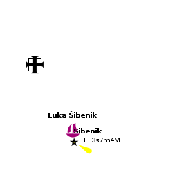
Anchorages
Luka Šibenik
Uvala Sveti Petar
There are some other options outside of the port of Šibenik and on the Kanal Sv Ante, but the wind funneling along the channel needs to be taken into account.
Amenities
| Facilities | |
|---|---|
| Water |
|
| Electricity |
|
| Toilets | In D-Marin Mandalina and Marina Solaris |
| Showers | In D-Marin Mandalina and Marina Solaris |
| Laundry | In D-Marin Mandalina |
| Garbage | Bins behind the waterfront and in the marinas |
| Supplies | |
| Fuel |
|
| Bottled gas | Give details on cooking gas (Camping Gaz, butane, propane, etc) suppliers. If there are no suppliers on the island just enter "None" |
| Chandlers |
|
| Services | |
| Repairs | |
| Internet | WiFi in D-Marin Mandalina (extra charge) and in Marina Solaris |
| Mobile connectivity | Is there mobile telephone signal such as G4, G3, GPRS on the island? How strong is the signal? Are there any blind spots? |
| Vehicle rentals | Outlets in the city |
| Health | Opća bolnica Šibenik: +385 22 246 246 |
Provisioning
Numerous supermarkets and provisions shops in the town:
-
 Djelo [[Šibenik#Djelo|Djelo]] (Ultra) 43°44.013'N, 015°53.520'E A small grocery store at the SE corner of the quay (Obala Franje Tuđmana 2)
- Tommy [[Šibenik#Tommy|Tommy]] 43°44.156'N, 015°53.537'E A tiny supermarket on the main street, opened on Sundays (ul. Miminac 1; Mo-Sa 06:30-22:00; Su 06:30-21:00)
- Konzum [[Šibenik#Konzum|Konzum]] 43°43.980'N, 015°53.761'E A larger supermarket a bit off the old centre, across the street from the market place (ul. Ante Starčevića; Mo-Su 07:00-21:00; Su 07:00-14:00)
Daily market:
- Pijaca [[Šibenik#Pijaca|Pijaca]] 43°43.952'N, 015°53.749'E Fruit, vegetables, meat and fish (ul. Stankovačka 9, Mo-Sa 06:00-13:00, Sun 06:00-11:00)
Eating out
![]() Pelegrini [[Šibenik#Pelegrini|Pelegrini]] note in particular this Italian restaurant, right across the square from the St. Jacob's Cathedral.
Pelegrini [[Šibenik#Pelegrini|Pelegrini]] note in particular this Italian restaurant, right across the square from the St. Jacob's Cathedral.
![]() D-Marin Mandalina [[Šibenik#D-Marin Mandalina|D-Marin Mandalina]] restaurant & café/bar.
D-Marin Mandalina [[Šibenik#D-Marin Mandalina|D-Marin Mandalina]] restaurant & café/bar.
![]() Marina Solaris [[Šibenik#Marina Solaris|Marina Solaris]] restaurant.
Marina Solaris [[Šibenik#Marina Solaris|Marina Solaris]] restaurant.
![]() In the Town [[Šibenik#In the Town|In the Town]] plenty of bars and restaurants.
In the Town [[Šibenik#In the Town|In the Town]] plenty of bars and restaurants.
Transportation
- Buses to Zagreb and destinations along the coast.
- International buses to Vienna and several German cities.
- International airports of Zadar (62 km) and Split (60 km).
See Šibenik at the Wikivoyage for further details.
Tourism
The old town of Šibenik is full of narrow streets climbing up past the cathedral to the fortress of St Ana on a bluff at the NW end of the town. There are superb views from here of the Kornati Islands and the Šibenik channel. Šibenik’s crowning glory, however, is the 15th century Cathedral of St Jakob, built entirely in stone (including the barrel-vaulted roof), whose most impressive feature is a series of 71 heads carved by an anonymous 15th century sculptor all round the north and east walls, all apparently modeled by the 15th century citizens of the town. From the town, one can also motor up the winding channel of the Krka river, hemmed in by limestone cliffs and lined with mussel farms, to the ACI marina at Skradin and the wonderful Falls, a few hundred metres upstream.


Friends
Contact details of "Cruiser's Friends" that can be contacted for local information or assistance.
Forums
List links to discussion threads on partnering forums. (see link for requirements)
Links
For other useful websites, see Croatia.
References
See entry for Croatia.
Comments
We welcome users' contributions to the Wiki. Please click on Comments to view other users' comments, add your own personal experiences or recommend any changes to this page following your visit.
Verified by
Date of member's last visit to Šibenik and this page's details validated:
- July 2004 --Athene of Lymington
- Sep 2016 --Vadim
| This is a usable page of the cruising guide. However, please contribute if you can to help it grow further. Click on Comments to add your personal notes on this page or to discuss its contents. Alternatively, if you feel confident to edit the page, click on the edit tab at the top and enter your changes directly. |
| |
|---|
|
Names: Athene of Lymington, Salacia |