North Atlantic
From CruisersWiki
| North Atlantic
|
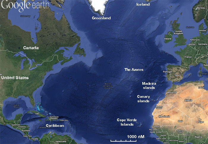
The Atlantic Ocean is bounded on the West by North and South America. In the North and Northeast, it is separated from the Arctic Ocean by the Canadian Arctic Archipelago, Greenland, Iceland, Jan Mayen, Svalbard, and mainland Europe. It connects to the Arctic Ocean through the Denmark Strait, Greenland Sea, Norwegian Sea, and Barents Sea. To the East, the boundaries of the ocean proper are Europe, the Strait of Gibraltar (where it connects with the Mediterranean Sea, one of its marginal seas, and, in turn, the Black Sea), and Africa. In the Southeast, the Atlantic merges into the Indian Ocean, the border being defined by the 20° East meridian, running South from Cape Agulhas to Antarctica. While some authorities show the Atlantic Ocean extending south to Antarctica, others show it as bounded at the 60° parallel by the Southern Ocean. In the southwest, the Drake Passage connects it to the Pacific Ocean. A man-made link between the Atlantic and Pacific is provided by the Panama Canal. Beside those mentioned, other large bodies of water adjacent to the Atlantic are the Caribbean Sea, the Gulf of Mexico, Hudson Bay, the Arctic Ocean, the Mediterranean Sea, the North Sea, the Baltic Sea, and the Celtic Sea.
Covering approximately 22% of Earth's surface, the Atlantic Ocean is second only to the Pacific Ocean in size. With its adjacent seas it occupies an area of about 106,400,000 square kilometers (41,100,000 sq mi); without them, it has an area of 82,400,000 square kilometres (31,800,000 sq mi).
Cruising the region
Add any cruising recommendations. If not applicable delete this section.
Charts
- BA
- 92 - Cabo de Sao Vicente to Strait of Gibraltar
- 94 - Southern Martinique
- 142 - Strait of Gibraltar
- 144 - Gibraltar
- 366 - Arquipélago de Cabo Verde
- 956 - Guadeloupe to Trinidad
- 1448 - Gibraltar Bay
- 1831 - Arquipélago de Madeira
- 1869 - Gran Canaria to Hierro
- 2485 - Approaches to Barbados
- 3578 - Eastern Approaches to Gibraltar
- Imray-Iolaire
- A4 - Guadeloupe to St. Lucia
- B2 - Barbados
- Chart 100 - (conical projection) North Atlantic Passage Chart
- C19 - Cabo Finisterre To Gibraltar
- C20 - Gibraltar to Arquipelago dos Azores and Islas Canaries
- E1 - Azores
- E2 - Canary Islands
- E3 - Madeira and Porto Santo
- E4 - Cape Verde
- E5 - Bermuda
- NIMA
- 2521 - St. Lucia
- 51017 - Ra's Beddouza to Cap Juby including the Arquipelago Da Madeira and Islas Canarias
- 51022 - Cap Juby to Baie du Levrier including the Canary Islands
- 51260 - Islas Canarias (Western Group)
- 51261 - Arquipelago Da Madeira
- 51262 - Baia de Porto santo
- 51263 - Baia Dp Finchal and Praia Formosa
- 51342 - Ilheus Selvagen
- 51500 - Cape Verde (Northern Part)
- 51540 - Cape Verde (Southern Part)
- 52031 - Strait Of Gibraltar To Balearic Isl
- 52039 - Strait of Gibraltar
- 25485 - Approaches to Barbados
- 2554 - Martinique
Weather
Give weather conditions in the region or refer to another page (a country?) that covers these conditions.
Sources for weather information:
Currents & Tides
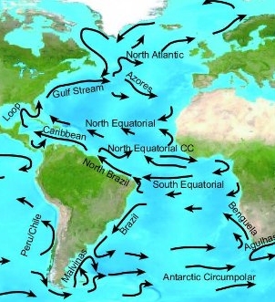
Give information on tides & currents.
Communication
Also see World Cruiser's Nets.
Any navigation notes here. If this section does not apply remove it.
Health & Security
Submit any health warnings/information and any security details here. If this section does not apply remove it.
Passages
Popular passages & best timing, etc. (E - West & W - East)
- Trans-Atlantic, Europe to Caribbean
- Trans-Atlantic, Caribbean to Europe Passage
- Trans-Atlantic - Canada to Europe
- Trans-Atlantic - Europe to Canada
Countries, Ports, Anchorages, and Islands
| Countries Europe | Countries Africa | Countries America | Islands & Groups |
Friends
Contact details of "Cruiser's Friends" that can be contacted for local information or assistance.
Forums
List links to discussion threads on partnering forums. (see link for requirements)
Links
- Greenland route info is about half way down page TELL-TALES
References
- Anne Hammick: RCC Pilotage Foundation, Atlantic Islands Cruising Guide: Azores, Madeira Group, Canary Islands and Cape Verdes, Imray Laurie Norie & Wilson; 5th ed edition (December 11, 2011), ISBN 978-1846233364
- Anne Hammick and Gavin McLaren: RCC Pilotage Foundation, Atlantic Crossing Guide, Adlard Coles; Sixth Edition edition (October 1, 2010), ISBN 9781408113806
- Jimmy Cornell, World Cruising Routes, International Marine/Ragged Mountain Press; 6 edition (March 14, 2008), ISBN 978-0071592895
- Jimmy Cornell, World Cruising Handbook: Covering All the Maritime Nations of the World, Adlard Coles Nautical; 3rd edition (July 31, 2001), ISBN 978-0713658279
Comments
We welcome users' contributions to the Wiki. Please click on Comments to view other users' comments, add your own personal experiences or recommend any changes to this page following your visit. Personal experiences?
| This is a usable page of the cruising guide. However, please contribute if you can to help it grow further. Click on Comments to add your personal notes on this page or to discuss its contents. Alternatively, if you feel confident to edit the page, click on the edit tab at the top and enter your changes directly. |
| |
|---|
|
Names: Lighthouse, Magwas, Istioploos |


